Sailing the northwest coasts
The circumnavigation of Corsica through storms
Sailing the northwest coasts
The circumnavigation of Corsica through storms
In the "Greek" Cargese ... and in the moss of Porto!
We rounded Capo di Feno and with the big pelagic waves on our left bank, we were entering the third large gulf of the western side of Corsica, the gulf of Sagone.
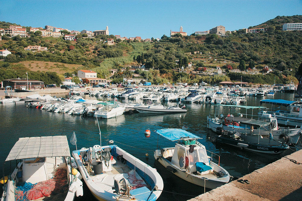
This bay is surrounded by high hills without much vegetation, and is characterized by its huge, flat beaches. There are several small settlements on the hillsides, but the largest village and only port of the bay is Cargese, located at its northern end.
Cargese was also one of our main destinations, since it is the only "Greek" village in Corsica, also known as Karyes. The village has its own special history, which is really very interesting, since its inhabitants are Maniates (see related insert).
We were outside the spacious harbor of Cargese and observed with special interest everything around us. At the left end of the buka is the gas station where we pulled over to stock up on fuel. The gasman, seeing the "Hellas-Corsica" logo on the inflatable, showed particular joy and certainly did not believe that we had arrived here by sea. He welcomed us to the Greek village and at the same time introduced us to his partner, whose last name was Greek.
We talked for quite some time and finally he urged us, around 14.00 in the afternoon, to meet at Capo Rosso, a few miles to the north. He was going to pass from there with his small plane, with the intention of doing some advertising photos from above, and he wanted us to be in his shots with the inflatable.
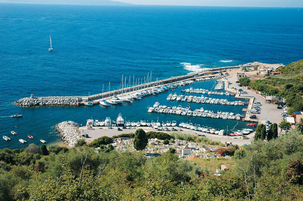
After making our appointment we slowly entered the port, which was suffocatingly full of local main boats.
We finally managed to tie up to the head of a floating platform, our stern sticking out quite a bit from the rest of the boats.
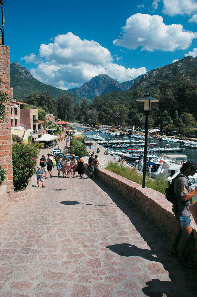
We climbed the long breakwater and photographed the village that is built high on the hump of the green hill. The two churches of the village stand out between the houses, one Orthodox and one Catholic, facing each other. The image of the port, with the village perched above it, is certainly very picturesque and the whole place is a very peaceful place, away from the hordes of tourists. It was the fifteenth of August, but the absence of people at the port made us feel that summer had not yet arrived. We took a short walk to the north side of the harbor where the very wide waterfront is. A diving club, a cafe and four restaurants exist here, but the absence of people is evident. At one point we met a picturesque local, who offered to take us to the village.
Everywhere, the scent of Greece!
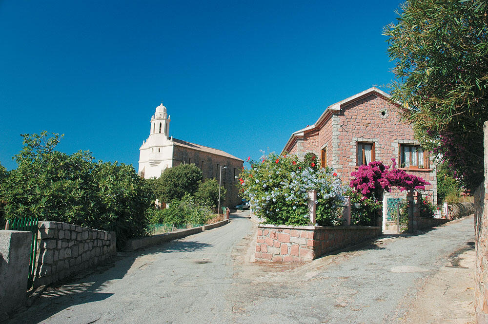
After a few minutes of driving on the uphill paved road we arrived outside the Orthodox church of Agios Spyridon. Built of local stone, with its tall bell tower rising majestically towards the sky, it is a very beautiful sight.
There was no soul. Only one local was sitting on the terrace, under the only olive tree just before the entrance, reading his newspaper carelessly. We greeted him and approached the wide open wooden door. Above it, on the long and narrow chipped stone, the inscription "house of God" is carved in Greek capital letters. Next to the wooden door is a small marble plaque commemorating the visit of the Union of Mani Associations in July 1965. In the vestibule of the church is hung a text in French which tells how the Maniates, who sailed from Oitylo in the Peloponnese, arrived and took root after many hardships in this distant place.
Moving towards the interior of the temple, we were dazzled by the large icons and hagiographies that occupied the entire height of the walls. Their colors were so vivid and perfectly preserved, that they gave the impression that their creation had just been completed. But the orthodox church of Agios Spyridon started to be built in 1820 and was completed after about twenty years. Without any doubt, it is a real gem for Cargese and a living historical - and of course Greek - monument.
Our emotion was great and it became even greater when, wandering through the uphill streets of the village, we noticed traces of Greece everywhere... Streets with Greek names, such as Rue de Grece, Rue de Vytilo, Rue de Magne, businesses with Greek names, such as Restaurant Thalassa, Hotel Helios, Residence Itylon, marble inscriptions declaring the properties or donations of the Maniats, while on some balconies the Greek flag was flying!
At one point we found ourselves a few meters behind the Latin church, where the wonderful cafe "A Volta" is located.
From its open-air lofts we admired the most beautiful panoramic view of the port, but also of the entire Sagone bay. From there we climbed to the highest point of the village, where the large playground is located, from where we got an amazing view of the northern gulf de Pero, with the incredible sand beach stretching along its head.
Our wandering through the alleys of Cargese took several hours and we finally arrived at the small square, which is essentially a crossroads where the road leading north to Piana meets the road going down to Ajaccio. And while in the alleys of the village we rarely met anyone, in this small square there was intense traffic.
The two cafes were full of people and after a long wait, we finally got comfortable at a small table. After drinking our invigorating coffee, we began to descend towards the port. We made a short halt, a few yards from its north-east side, and visited the village cemeteries, where many graves are inscribed with Maniac names.
Thus ended our short acquaintance with this Greek village of Corsica, which, beyond the moments of emotion, watered us with its catalytic peace, which we needed so much after so much sea that we traveled. Without being a first-line destination, Cargese is definitely a special place for Mediterranean Hellenism.
The story of Cargese
Since 1663, the Maniates were in negotiations with the Genoese, with the aim of finding a new land to host them, so that they could escape the Ottoman occupation. Several years later, the Genoese proposed Paomia in Corsica, an area located 50 kilometers from Ajaccio. The Genoese authorities made sure to change the surnames of the Greeks, changing their endings to -acci. Thus, names such as Papadakis, Drakakis, Tzannetakis were transformed into Papadacci, Dracacci, Zannetacci. So in September 1675, 730 Maniatians boarded the ship Le Saveur from the bay of Oitylos bound for Genoa and from there to Corsica, which was under the rule of the Genoese.
Marbeuf showed great interest in the Maniates and allowed them to build their own village, where Cargese is today. When the relations between the Greeks and the Corsicans normalized, the first mixed marriages began to take place, with the result that 2,000 people live in Cargese today, many of whom are descendants of the Maniates. But we will hardly find someone who can articulate even a few Greek words. Otherwise, the whole of Cargese has a flavor of Greece and its inhabitants are conscious of their Greek origin, even keeping their Maniac surnames. After all, Cargese, throughout France, is promoted as the "Greek village".
Destination: Bay of Porto
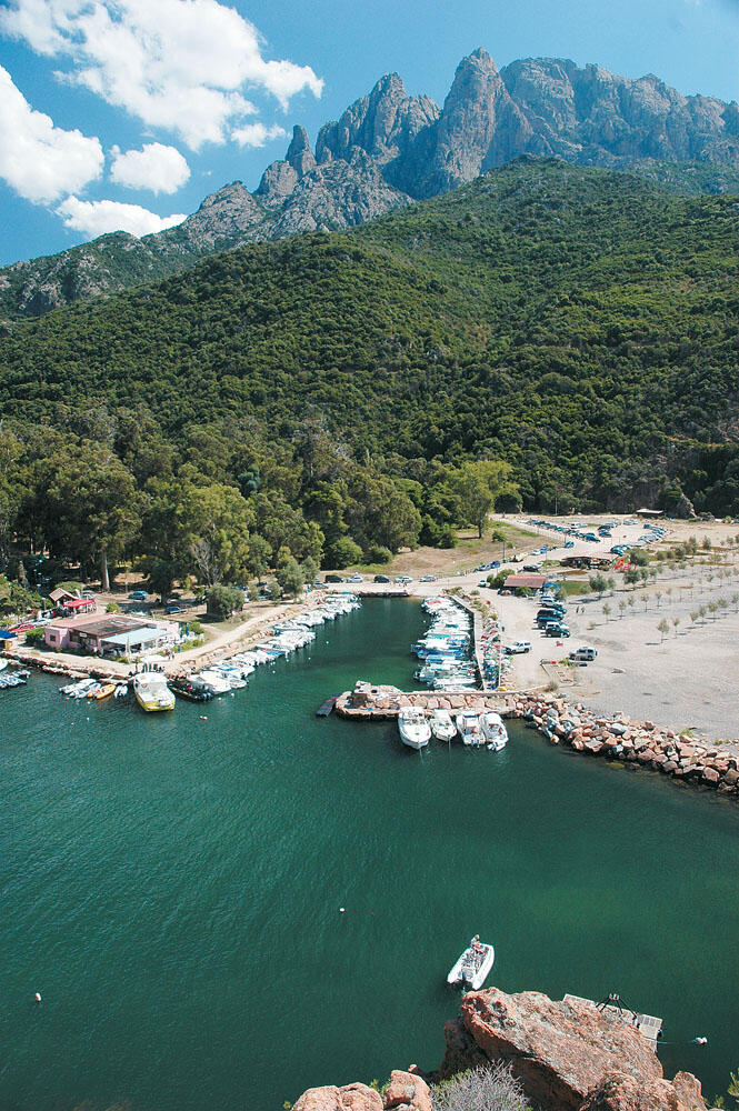
It was just after noon and the pelagic silent waves of the pounenti had reached their maximum height. We left the bay de Pero on our right, and were only six nautical miles from Capo Rosso, the southern extremity of de Porto, which is the fourth and last bay on the west side of Corsica.
The entire bay of Porto constitutes an important special geological complex and belongs to the regional national park of Corsica. It is the most impressive bay of all, since its entire coastline is an amazing sight. It is no coincidence that in 1983 it was declared a world cultural heritage site.
Three large ridges, the Elbo peninsula to the north, the small Senino peninsula which is actually inside the gulf, and Cape Rosso to the south, demarcate three distinct areas within this gulf. The first area includes the Scandola massif and the Girolata cove, the second the mouth of the Gulf of Porto with its enchanting harbor, and the third concerns the famous "les Calancques", located below the village of Piana to Capo Rosso.
All three of these areas of the bay of Porto are without a doubt the most spectacular spot in Corsica, and offer us some of the most shocking images that we come across in the entire Mediterranean.
Amazing sea caves, large arches, inaccessible beaches with wonderful waters, scattered islets and rocks in unique formations that make especially happy those who are lucky enough to sail these places.
Of course, the most fascinating of all of these - which I believe is also the main reason that has made the bay of Porto famous around the world - are the crimson granite rocks, which extend along the entire length of the coastline and fall from a great height in dark waters, giving us a rare and exciting sight. The color of the rocks is so special, especially at sunset, that you think the rugged rocks are really on fire...
Once we crested Capo Rosso, right on the turn of the cavo, we encountered several caves in a row and wide clefts in the rocks that descend from a great height. A few tens of meters further on, a beautiful bay is formed, inaccessible from land. The beach is paved with pebbles, but the color of the water is wonderful. The weather was getting pretty bad and with the wind bothering us, we got close to the shore and had a blast. At this point, the meeting with our friend Frank from Cargese, who was going by plane...
We were moored just at the descent of the crimson granite cliffs which tumble vertically into the sea from 331 meters, and looking up we could clearly make out the summit of Capo Rosso, where the circular stone tower of Turghiu was built. Just as they appeared, like colorful dots, some people who were on the roof of the tower and would surely enjoy an unforgettable view.
In vain we looked for a path that would lead us up to the tower. The rocks were so steep that they left no room for climbing. The only way to get there is to take the path that starts near the village of Piana and after several kilometers and three hours of hiking to reach the top of Capo Rosso.
The Turghiu tower located there is one of the 85 towers that the Genoese had built in Corsica and served as watchtowers, from where within a short time, with the use of fire and smoke, the whole island was notified and an alarm was sounded when it appeared in the sea enemy or pirate ships.
Not a few minutes passed, and we saw a small yellow plane making open circular flights over Capo Rosso. It was Frank who was photographing the red headland, and to help him spot us we began to make tight turns with the inflatable, slowly making our way out of the cove. At one point we picked up speed and the plane came alongside us, lowered quite a bit and took a parallel course with us until we entered the bay of Porto together. A little later we said goodbye to Frank, as the plane turned and, gaining height, turned towards Cargese...
We were already halfway across the bay and sailing fairly close to its southern shoreline. The sight of the red rocks continued to be impressive, but from photos we had seen we knew that somewhere up there was the famous area called les Calancques and it is one of the most impressive spots in Corsica.
It is a "stone garden" (as it is commonly called), consisting of incredible formations of red rocks.
They are located at an altitude of 400 meters, on the road that follows the extremely steep coast, and connects Porto with the village of Piana. The steep granite rocks and their incredible formations, combined with the breathtaking view towards the bay of Porto, are undoubtedly one of the most beautiful landscapes of the island, as well as a very popular destination for thousands of people from all over the world.
From the sea we could not get a clear picture of this famous area and, with the promise that we would visit it after a few days by car, we continued our course towards the mouth of Porto bay.
The surprise!
Just before we approached the myho, our attention was drawn by a large canyon that descends from above and at its mouth into the sea it opens quite wide, forming the spectacular small beach of Ficajola. With incredible waters, nestled between the steep rocks and the presence of five or six small houses in the greenery, it is a magical corner of the southern side of Porto Bay. Of course, it gathers quite a few boats and a lot of people who come from the narrow, winding road that goes down the side of the canyon and reaches very close to the coast.
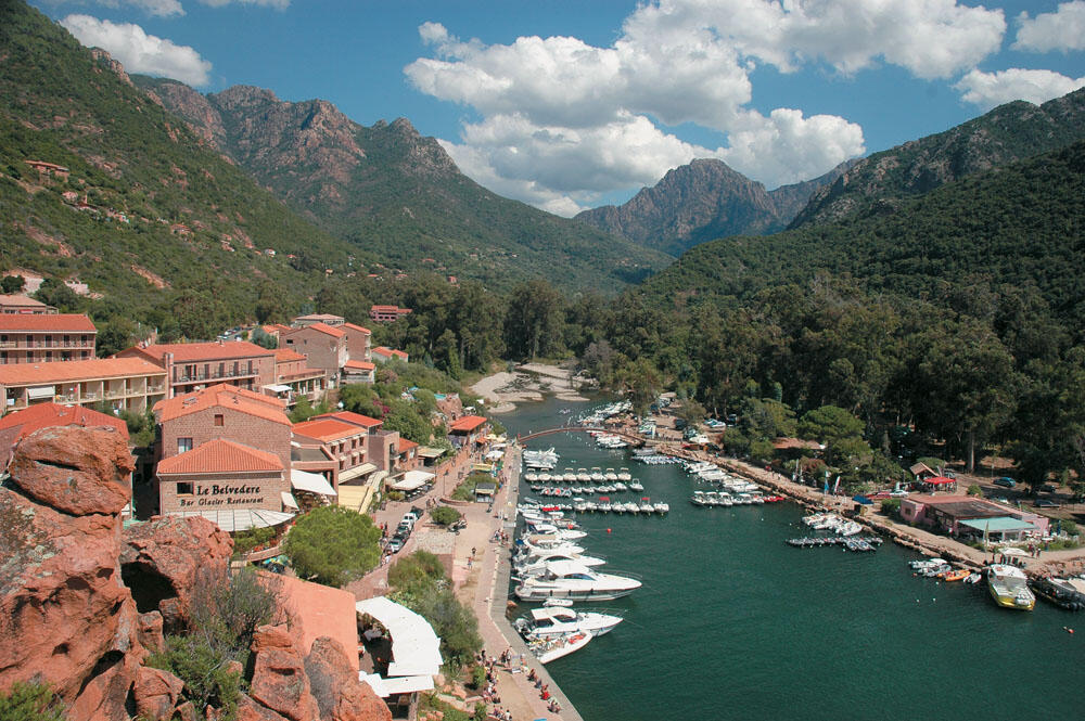
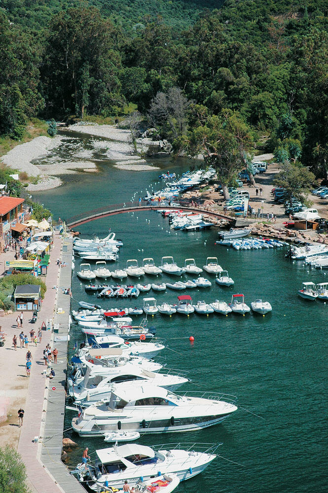
Approaching the deepest part of the bay we were fascinated by the magnificent landscape that spread out before us. We were right across from the mouth of a large river, which pours its waters into the sea, between a large, flat sand beach and a high rock that juts out several meters into the sea, on the top of which dominates an impressive Genoese tower.
Behind this rock and along the northern bank of the river is built the small village of Porto, from where the name of the entire bay comes.
From the planning of the trip we had noticed this small village and the excellent location it was built on, but in no case did we expect it to enchant us so much. Without any hesitation I would say that, together with Bonifacio, they are the most exciting parts of the western side of Corsica. The overall picture of the landscape, with the towering mountains surrounding this fairy-tale corner that is drowned in vegetation, is a rare and special treasure for the entire Mediterranean.
We stood spellbound observing this wonderful scenery, when we realized that it is very dangerous to enter the river, whose estuary is also the marina of the small village. The reason, of course, was the invisible silent waves of the punentis that burst right at the mouth of the river, the mouth of which was also narrow...
The only way to get through was to get in with enough speed so that the waves wouldn't wash us onto the rocks. We did not know, however, whether there were shoals or shoals at our entrance to the river, as every high wave that broke at its mouth looked like a great dam of water.

Luckily for us, a diving inflatable was coming out of the river at that time. We waited a while for him to move away and, without wasting time, the lever was pushed forward and we followed the tracks left by the diving inflatable. Breaking the advancing wave that blocked the mouth, we immediately found ourselves in the calm waters of the river.
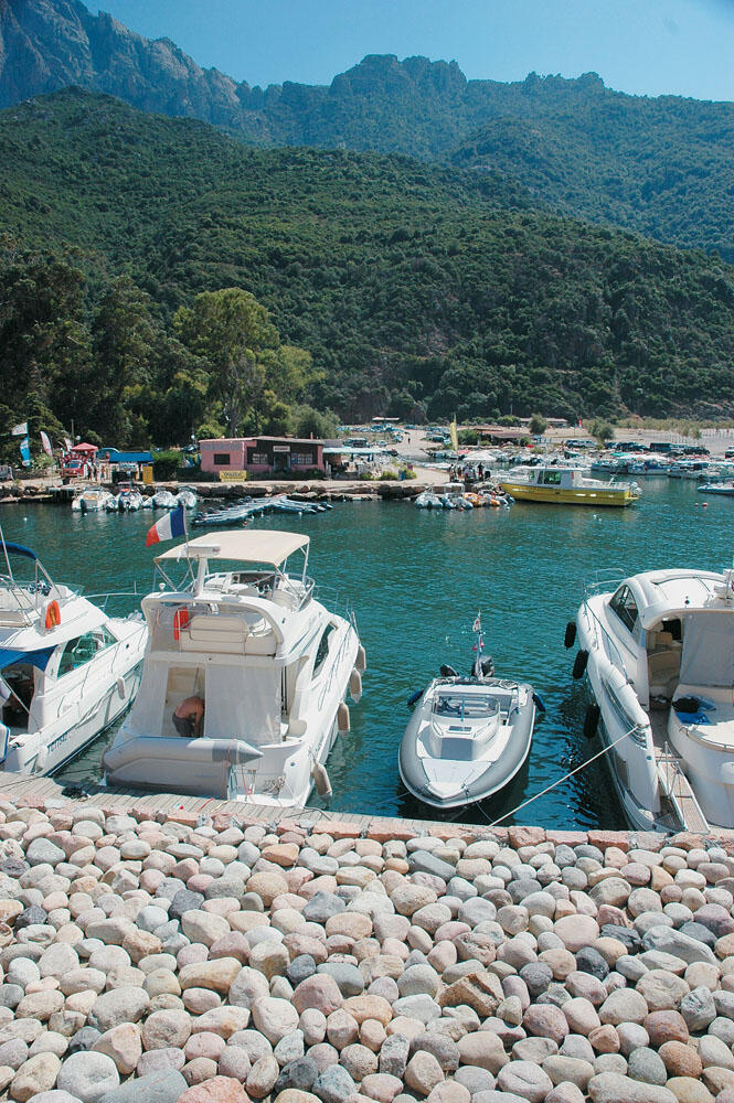
To our left began the waterfront of this particular marina, which was actually on the northern bank of the river. Directly opposite, on its southern bank, a long narrow cove is formed, which is crowded with boats. At the beginning of this river inlet is also the gas station. The marina continues for several tens of meters into the river, up to the iron bridge that connects its banks, and serves the passage of pedestrians. Anchoring on the stone-paved quay, we had the feeling that we were in the depths of some wild jungle.
Along it are many cafes and restaurants, while towards the end there is a large diving center. Just above these shops are the few but impressive stone hotels, which offer a wonderful view of the river. The whole place is wonderful, and looks like a magical picture out of the most beautiful fairy tale.
Porto is a very small seaside, and at the same time coastal tourist resort, with a special charm. In the summer it gathers a lot of people and is a very good strategic point, for our wanderings in the very interesting and extremely spectacular neighboring areas.
We went up the cobbled street that leads to the top of the rock, which is like an island next to the mouth of the river. Very soon we reached the square stone tower which with its presence makes this place even more beautiful. It was built in 1549 (at the same time when the rest of the Genoese towers were being erected in the most strategic parts of the island) and, completely renovated since 1993, it is the most ideal point from which one can admire the surrounding area.
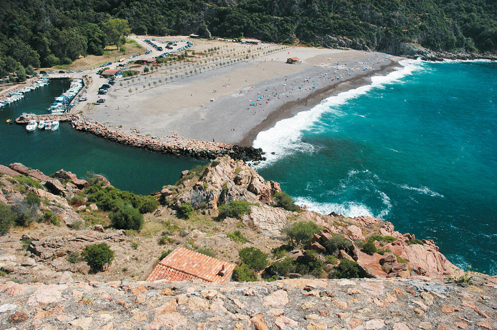
We ascended by the external staircase to its roof, from where the sight is unique. Wherever you look, you can't help but feel fascinated and happy by the images recorded in your memory. To the west opens the bay of Porto surrounded by towering crimson rocks, while to the east and behind us the sight is shocking as we admire the river emptying into the sea after its long course between the impressive gorges that can be seen inland.
On the south side, right under our feet and next to the mouth of the river, stretches the wide beach...
We were for a long time on the Genoese tower but our eyes did not say to be satisfied. Finally, we went down inside, where a small museum is also hosted with exhibits that chronicle the most important events that took place in this place. A little further down the rock, there is still a small folklore museum, inside a low stone house.
Returning to the quay, we felt a strong desire to prolong our stay in this place, although we knew we were running out of time. We crossed to the opposite bank of the river, walking over the tall iron bridge. An oasis of towering trees covers this side, just behind the long beach. In the dense vegetation is a small golf course, in whose cafe we sat for a few breaths of rest. Not that we were physically tired, but we wanted to put in order the amazing images that the entire Porto bay kept giving us. And after enjoying our coffee under the spectacular eucalyptus trees, in a completely quiet and unspoiled landscape, we made our way to the inflatable.
Clearly excited, we left the mouth of the river and the small village of Porto in our stern, and approached the northern side of the bay of Porto sailing close to its shores. Four nautical miles separated us from the small peninsula of Senino.
...keep Ribbing!