Sailing the northwest coasts
Sailing the northwest coasts
With a south-easterly course ... just before the return
Leaving Bastia at our stern, which we really loved, as our base for our tour of the amazing Corsican hinterland, our bow turned south. We intended to go down low and spend the night in a safe bay on the south-east side of the island, having Santa Giulia as our first choice for our last night in Corsica.
Santa Giulia is five miles south of Porto Vecchio, and from pictures we had seen it looked like one of the nicest beaches on the island. We were 75 nautical miles from Bastia, but we had a whole day ahead of us so we cruised the calm sea of the east coast at low speed, exploring the place and enjoying a wonderful cruise.
The whole of this part of Corsica is level and resembles an immense plain where we meet in a row many lakes, the eastern limits of which reach to the coast-line. It is a fairly monotonous route, since your path is always parallel to the flat sandy beaches that stretch for many kilometers, without changes, without coves and steep coasts. We were traveling along a vast plain, with almost zero altitude, but the lush vegetation and the very tall trees, a result of the many lakes and also the rivers that flow on the east coast, beautifully filled our field of vision.
14 nautical miles south of Lake Biguglia is Porto Campoloro Marina. In the distance you can still see a whole forest of sails protruding from the protective blocks of the marina. We continued our coastal drive past lagoons and incredible jungle-like nature. Somewhere there, between lakes Diane and Urbino, is the former capital of Corsica, Aleria (also known as Alalia), which was founded in 546 BC. from the Phocaeans of Ionia.
30 nautical miles south of Porto Campoloro is the large marina Solenzara, at B 41° 51΄ 36 and E 9° 24΄ 22. We slowly entered through its entrance facing the sirocco and took a short tour. The Solenzara marina is a real gem for the area and provides all the facilities for the numerous boats it accommodates. There is a large boat slip, gas station and engine repair shop, while a little further on there are grocery stores, restaurants and cafes in a row, serving the needs of visitors.
While the entire eastern coastline of Corsica, from Bastia to Solenzara marina, is a vast and almost complete stretch of sand for many nautical miles, without forming any bay at all, from here on the landscape slowly begins to change. The green hills rise to a considerable height and the coasts become steeper, even forming very large and deep bays.
Three nautical miles north of the bay of Porto Vecchio we meet the large bay of Pinarellu. Its entrance faces the grego and accommodates many boats that are anchored in the sea. The most beautiful part of the bay is its southern part, which ends at the small islet with the characteristic Genoese tower on top.
In the bay of Porto Vecchio
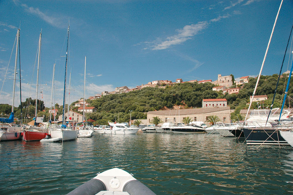
Vecchio is the largest bay on the eastern side of Corsica, since it enters the land at a length of four nautical miles, while its width in some places reaches up to one nautical mile. It is one of the busiest bays in Corsica and the boat traffic is very high. Its depths, however, are very shallow, while the scattered dry areas hide dangers. For this reason there is a marked sea corridor, which leads safely to the marina located at the mouth of the large bay.
There were too many boats leaving the marina so we had to wait outside the green light of the buoy until the traffic died down. A few meters to the right of the bow is the gas station, where the queue of boats waiting to fill up was very long. We waited for a long time until it was our turn, but we had no choice since we had to pack our tanks, since the next day we would be making the first long passage back. We then headed to the marina offices and finally managed to find a free berth to stay a few hours.
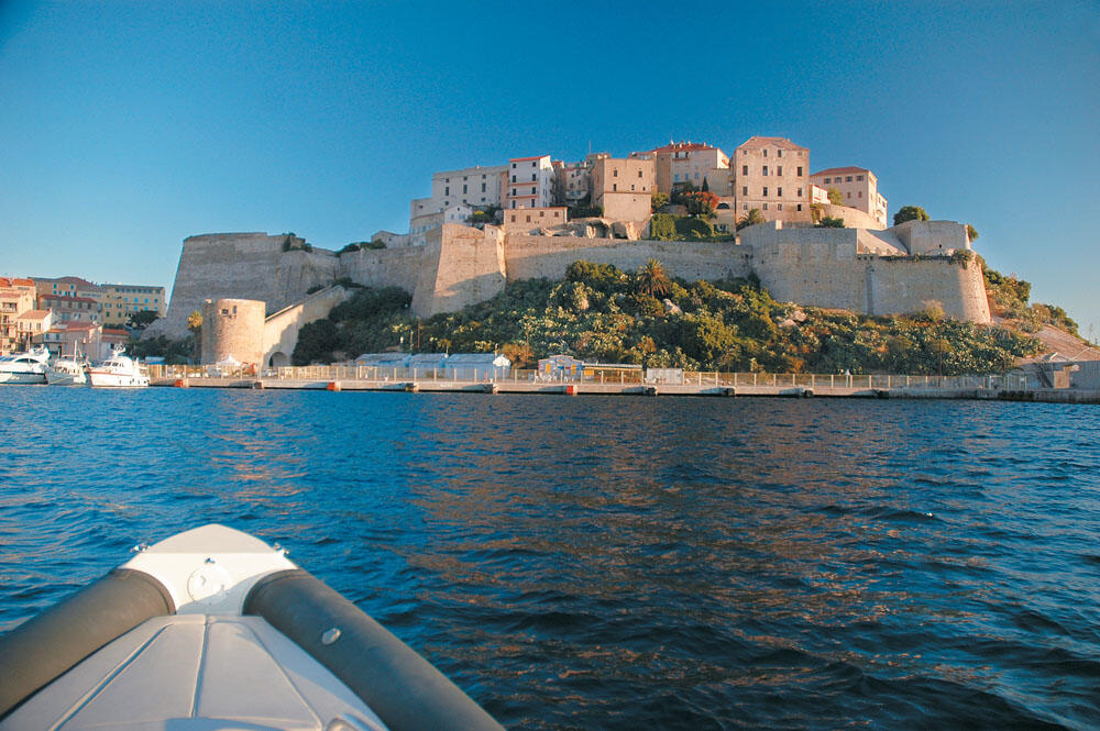
Very quickly we caught the trolley train that starts every hour outside the marina and soon it took us to the small castle town of Porto Vecchio. Built on top of the green hill on the northern side of the harbor, it seems to watch over the entire bay.
We stopped for a while outside the Porte Genoise, which is located on the south side of the castle town and was the only entrance to the city during the Genoese period.
It is a small stone portico sealed by a very strong door, the mechanism of which still works today. Above the gate is placed a large cannon facing the port, from where all the supplies arrived at that time. For a long time we wandered through the narrow streets that are full of shops, restaurants and cafes, ending up in the "Liberty Square" in front from the tall stone bell tower of the church built in 1868. We enjoyed a refreshing coffee under the dense shade of the trees, and after a few moments of rest we made our way to the marina.
We were slowly getting out of her mouth and the boat traffic was still heavy. This is due to the fact that many choose Porto Vecchio as a starting point and base for their daily excursions. Which is of course not accidental at all, since around the large bay there are several coves and many sandy beaches, which are in fact among the most beautiful on the island. A few miles north - and mainly south of the bay of Porto Vecchio - we find truly heavenly shores. The only drawback is that in the heart of summer it becomes inseparable from boats that flood every beach, and one cannot enjoy them and enjoy them in peace.
Three miles down the southern tip of the bay of Porto Vecchio, directly opposite the Cerbicale islets, stretches the magnificent Palombaggia coast. The unique waters, the white sandy beach that stretches for two and a half kilometers and the beautiful pine trees along it, constitute one of the most popular beaches in Corsica. Many boats are moored in Arodo, while thousands of bathers visit it during the summer months.
Crossing inland
Corsica is not only famous for its exotic beaches and seaside castle-states. And one cannot claim to have known Corsica if one does not wander in its mountainous part for which it is equally famous.
That's what we did and we were more than compensated! The final destination of our all-day mountain wandering was the famous "Les Calancques" area.

After a few turns we reached the mountain village of Piana which is built at 438 meters, on a small plateau. It is a very beautiful village with lovely stone houses and everyone stops here for a few moments of relaxation. Many even live in Piana, which is an excellent starting point, since very close to it are some of the most beautiful areas of Corsica, while from here start wonderful paths that end up in amazing places, attracting hikers from all parts of the world.
We had crossed Corsica, for, starting from Bastia on its north-east side, we reached westward to the Gulf of Porto. Perhaps this is the most beautiful mountain route of the island.
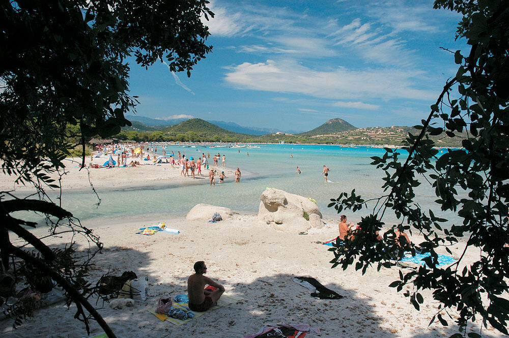
In the exotic Santa Giulia
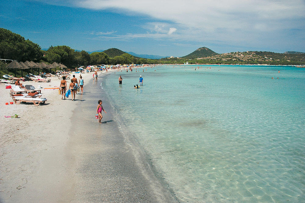
A breath further south opens the amazing bay of Santa Giulia, which was to be our last stop on Corsican soil. We were truly ecstatic when, after halfway across the bay, the deep blue of the sea gave way to a stunning turquoise color that spread across the entire bay.
As we progressed, the waters became shallower and shallower, while the all-white sand beach that is laid on the bottom made the image of this cove even more magical. The image of the wooden jetty, supported by vertical pilings that seemed to float above the incredibly clear waters, was one of the most beautiful images we have ever seen. We approached at very slow speed so as not to disturb the bathers, and tied up on the north side, alongside the tenders which were temporarily tied up.
Directly in front of the wooden pier is the Moby Dick Hotel. Its low and very elegant installations, nestled in the dense vegetation, not only do not alter the natural landscape, but on the contrary highlight it even more. If we didn't see its wooden sign, it would probably go unnoticed, since only the low dark-colored roofs could be seen under the pines of the coast.
At some point we reached the southern end of the all-white sand, where a narrow channel ends that connects the cove with the lake that exists right behind it. We climbed the slope of the low hill and among the thick foliage of the trees we observed a truly heavenly landscape. The entire coast of Santa Giulia is a vast and well-formed pure white sand, with transparent turquoise waters that would be the envy of even the most famous exotic island. Without any doubt it is an amazing place, a real gem for the whole island.
We kept walking along the sandy beach and, without thinking about it, decided to spend the night here. To sleep on board, a few centimeters above the dreamy waters, strapped to the side on the wooden jetty. We wanted to say goodbye to Corsica from here, and as we were leaving it behind us, the image of Santa Giulia would be the one that would accompany us on our long voyage on the open sea.
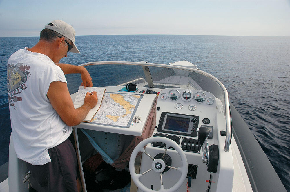
Night had covered everything but we couldn't sleep that night. It was past midnight and we found ourselves charting the long way back. We spread the nautical chart of the Mediterranean in the cabin and began to count miles, mark refueling points, and choose places to spend the night. After a while, our final course was set, where great importance was given to the local weather of the sea areas we would cross, depending of course on the autonomy of the boat. It was certain that the weather would be fine - at least up to the Straits of Messina - and so there was no reason to worry.
We would cross the Tyrrhenian Sea and the Ionian Sea in three days, during which time we had to cover the 650 nautical miles to Plataria. Essentially, we had two big gaps in front of us. One with our bow facing the siroko, and one with our bow facing the grego. We would stop only for supplies and for the night, aiming for every sunrise and sunset to find us at sea...
I don't know if our thoughts finally let us sleep at all, but before he even scratched we were on our feet.
The famous forest d'Aitone
Following the D 84 road, we drove to the famous forest d'Aitone. It is the most beautiful of Corsica, it extends over 10 square kilometers, between Evisa and the Col de Vergio, and is a unique destination for thousands of visitors who make day trips, enjoying the beautiful and unspoiled nature that gives truly enchanting images. Spectacular gorges, waterfalls, small cascading pools and wonderful trails attract many hikers of all ages every day. Dozens of cars were parked in many parts of the road, the passengers of which had to walk long distances until everyone found their shelter, either on some flat rock overlooking the impressive and deep ravines, or in the river bed to enjoy their bath in Lilliputian natural pools.[/three_fourth]
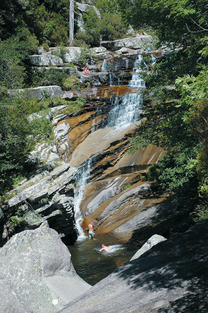
At some point on our route, just before Evisa, the cars parked on the side of the road formed a queue of hundreds of meters, which did not leave us indifferent. In less than ten minutes we reached the depth of the canyon, where all nature bowed to the spring... song of the running waters. Every rock and corner was occupied by small groups relaxing on their spread towels, listening to the sounds of the small waterfalls. Where the waters pooled, forming natural pools, it became inseparable, mainly by splashers who attempted spectacular dives. Paradisiacal landscapes that strongly reminded us of our own "pedestals" in Samothrace and our thoughts traveled for a while to the distant homeland...

On our way back
It was still night and our bow was slowly coming into its distant turn. 102 degrees course and 191 clear miles to Ventotene in the Pontine islands. After three hours of sailing, our position was N 41° 13΄ 51΄΄ E 10° 53΄ 30΄΄. We kept our course steady and left Corsica to our west. We were already 73 nautical miles from the Straits of Bonifacio, and the Tyrrhenian Sea had taken us for good in its wake.
After eight hours of incredible sailing, we approached the islet of Ventotene. We refueled and without wasting time we were back on board. After an hour we were cruising the southern shores of Ischia, known in ancient times as the Monkeys. On this volcanic island, the first Greek colony of Great Greece was founded by Euboeis, in the 8th century BC.
We prepared a coffee and left the inflatable unruly, drifting away from the deep dark sea. We only had 16 nautical miles to Capri, where we planned to spend the night. We were back in our old haunts, admiring once more the impressive vertical cliffs of the southern side of Capri.
Night found us anchored behind the famous Faraglioni, plotting the next day's course.
We had covered the 234 nautical miles very easily and would soon be starting the second leg of our return. We chose not to follow a coastal navigation and open the sea, directly marking the Strait of Messina at 150 nautical miles. Our course passed a little further east of Stromboli and so we intended to make a short stop at this islet, from which we were separated by 114 nautical miles.
Long before the next day dawned, the engine went forward and our bow pierced the darkness. As soon as it started to chop we increased our speed and reached 23 knots. The inflatable glided on the glassy surface of the sea in an almost unreal landscape, composed of absolute apnea, humidity and low light. For more than two hours we had this special experience covering a distance of 45 nautical miles until the sun began to rise behind the mountains of Italy. We were off the bay of Polykastro and enjoying the sunrise at sea for the second day in a row, sailing in a crimson sea.
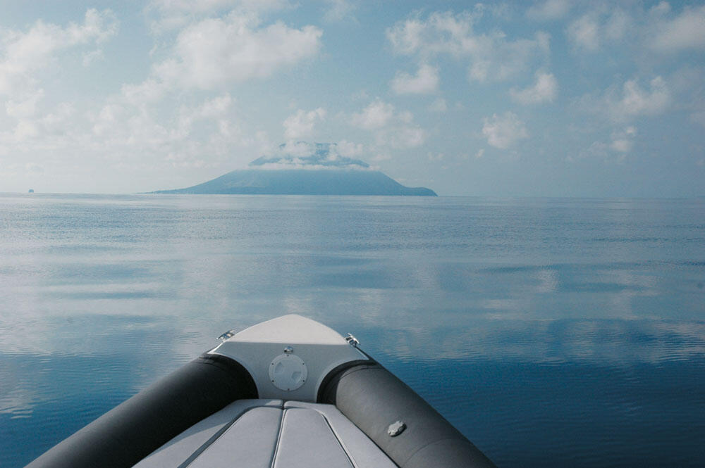
On the islet of Stromboli
It was half past eight and we still wanted 40 miles to Stromboli. The distance was enough, but the mountainous mass of the island began to be seen on the horizon. Stromboli is the most north-eastern of the Aeolian Islands and the only active volcano that has been "smoking" continuously for many centuries. That is why it is also known as "the Tyrrhenian Lighthouse". The thin clouds were reflected in the rippled sea, giving us an incredible sight as the water cut its surface at a speed of 33 knots. Although we had visited Stromboli in the past with the six-meter then Mostro, the incredible bonanza challenged us for a second tour.
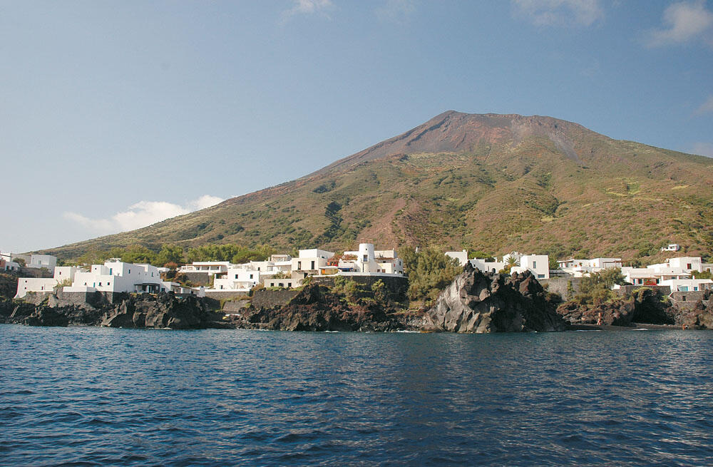
The appearance of Stromboli from a distance resembles a large crater, with a wide base, rising out of the sea. We approached the northwest side of the island, where the pitch-black and almost sandy slope dominates, disappearing into the deep, dark waters. We stopped for a long time to observe the top of the mountain, where the active crater is located, which continues to emit smoke, crowning the entire island. Every now and then, small stones hurled from the volcano tumbled down the pitch-black slope, leaving a continuous trail of smoke in their tumble.
We sailed very close to the north-east coast, where many small beaches are formed with black sand. Directly above, on the plateaus of the volcanic rocks, are built the white houses that have strong Cycladic characteristics. We rounded the north-east end of Stromboli, where many boats are moored, as there is no harbor on the island. From here begins the long black sandy beach that reaches the small pier where the gas station is located.
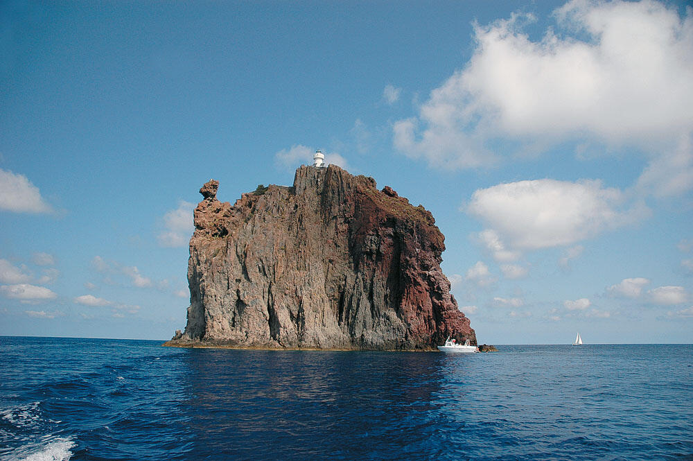
Behind this sandy beach where the locals pull their boats, is the main settlement of the island, with the bell tower of the San Vincenzo church standing out among the all-white houses. After fueling up, we visited the Strombolicchio rock located a mile northeast of Stromboli. This rock stands several tens of meters above sea level, and is one of the most important attractions for visitors to the archipelago.
Final line
The sea continued to look like a lake, and after this short wandering around Stromboli our bow returned to her course, marking the straits of Scylla and Charybdis, 38 nautical miles below. And while the entire Tyrrhenian sea was in torpor, the strait was seething with its evil.
In a short time we crossed the strait and soon we were out of its depths. Our bow turned to the west and the sea again looked like a lake up to Capo Spartivento. Climbing the cliff, we headed towards the grego marking Roccella Ionica. Although we still had several hours ahead of us, we preferred to spend the night here, since Roccella Ionica is the most beautiful place to spend the night in the wider area.
We had still covered 224 nautical miles and were getting ready for the Ionian crossing, which was also the last leg of our return. We decided not to go up to Kroton and take a course of 67 degrees, direct to Plataria at 192 nautical miles. Thus, we would also avoid sailing in the Gulf of Squillace, which often produces very rough seas.
Sunrise the next day found us sleeping in the little cabin. The accumulated fatigue did not allow us to get up before the break and so we left at seven o'clock from the port of the marina.
The sea for the third day in a row was unsalable and everything looked like we would have another enjoyable trip. We were quite far from the Italian shores, and the whole Ionian Sea looked like a vast lake.
Surrendered to the majesty of the vast blue, our thoughts traveled to the enchanting places we visited and only every hour we got up to make our mark on the ship's log. The sea gave us wonderful sailing and after seven hours we entered the bay of Plataria, completing 650 nautical miles in three days.
Altogether, on this voyage to Corsica we covered more than 2,000 nautical miles, in about twenty days. We may have been tired, but the joy of the journey and the happiness we felt overshadowed our exhaustion and only smiles and a deep satisfaction could be seen on our sun-tanned faces...
...keep Ribbing!