With a south-easterly course … just before the return
In the “Greek” Cargese … and in the moss of Porto!
With a south-easterly course … just before the return
In the “Greek” Cargese … and in the moss of Porto!
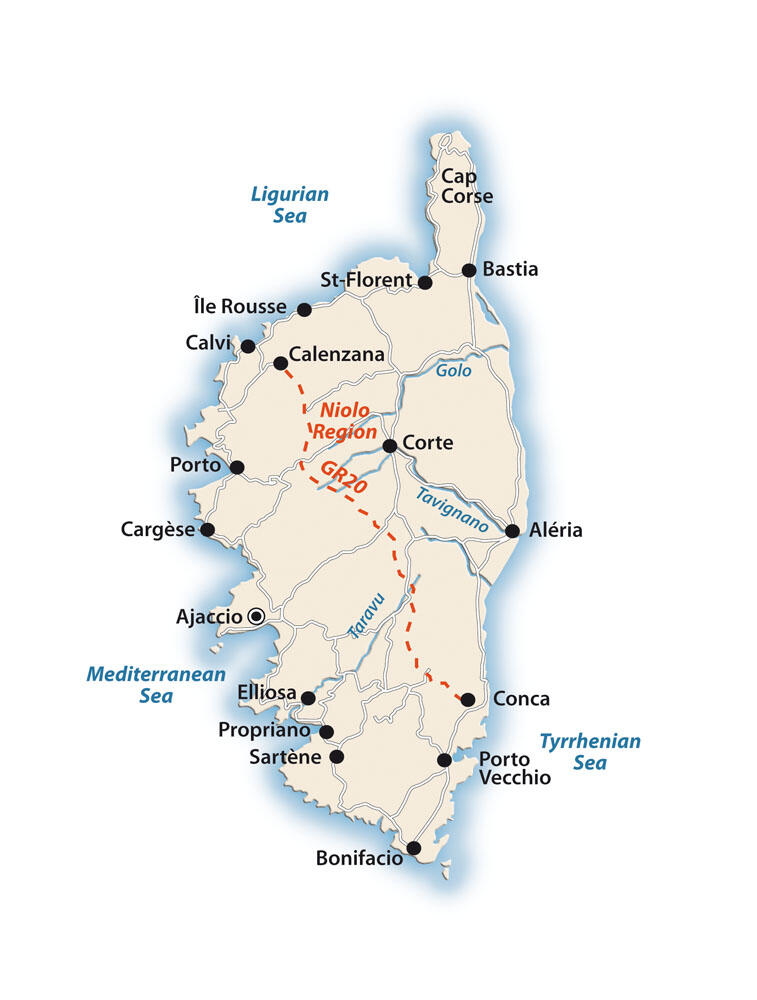
Sailing the northwest coasts
We left the mouth of the river and the small village of Porto at our stern, and approached the northern side of the bay of the same name sailing close to its shores. Four nautical miles separated us from the small peninsula of Senino.
In this part of the coastline there are one large and two smaller beaches, which gather few people. In a few minutes we reached the bottom of the Senino massif, which rises 619 meters above sea level and is a magnificent sight in itself. Between Cape Senino and the Scandola peninsula is the gulf of Girolata, which is also of great interest. On the southern side of its headland is the magnificent Tuara Beach, which is inaccessible by land.
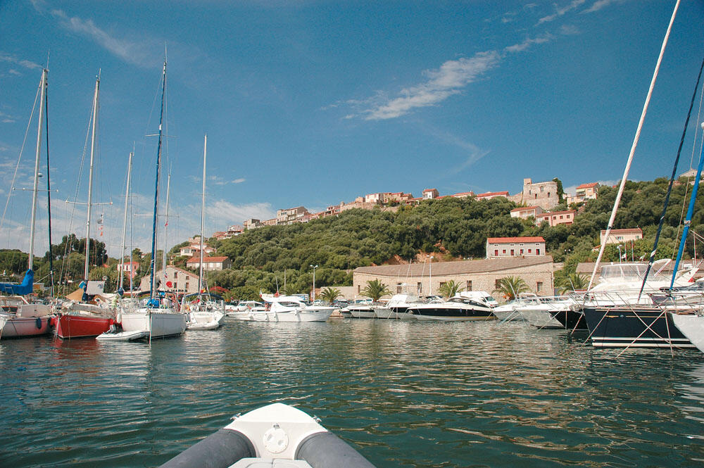
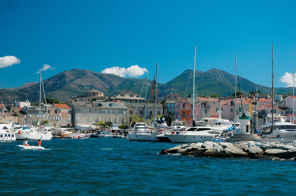
Our bow marked the northern side of the cape of Girolata Bay, where the village of the same name is located. A low hill that juts into the sea creates a lovely cove, which is an ideal anchorage completely protected from the westerly winds. Approaching, a veritable forest of sails revealed itself before us. There were so many sailing ships at anchor that we had to maneuver between them constantly. Arriving at the beautiful coast we temporarily tied up at one of the three piers that are in a parallel row, and serve the tenders and tourist boats that constantly transport people from Porto and Calvi. It is characteristic that this cove is one of the emblematic spots of Corsica, and is often featured on the covers of advertising brochures and travel guides of the island.
With the sun taking a breather before plunging into the vast sea, we rounded the outer side of the Scandola peninsula, bidding farewell to the bay of Porto, heading up the northwest coast of Corsica. We were only 15 nautical miles from Calvi, which was our next stop, and we were counting on getting there before night fell. The entire coastline, from Scandola to Calvi, is characterized by steep and inhospitable rocks, which offer no protection in the westerly weather.
Very soon we were under the impressive Revellata lighthouse, at the top of the cape of the same name. Turning to the eastern side of the cave, the weather stopped completely, while in the background the castle town of Calvi was clearly visible. But there was no reason to approach sunset, so we continued our coastal course on the eastern side of the Revellata Peninsula. We passed by a very small harbor that hosts a marine research center, and proceeding towards the neck of the cape we chose a small shore, where we spent the night.
In enchanting Calvi
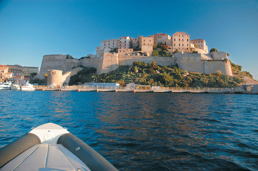
Dawn found us at sea. We approached under the high walls that surround the old town of Calvi and admired the magnificent castle town, which is built on top of the low cave. The multi-storied old houses inside the walls are painted in earth tones, and from afar they emphasize their long history. We returned to the eastern side of the bay, where the entrance to the large marina is located. From this side the sight is even more imposing.
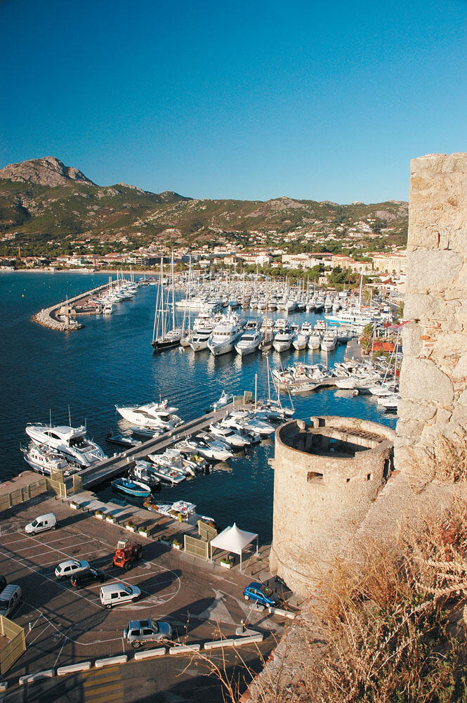
Directly in front of the old city walls begins the marina, which is full of large boats. It doesn't take long to realize that this place is a very popular destination that gathers a lot of people. It is not only the large number of boats that betrays this, but also the picture you see when you enter the marina, which cannot but excite you.
We quickly tied up in the position indicated by the marina officials and took the uphill road that leads to the west side of the castle town. There is also the large square of Christopher Columbus, since Calvi is one of the cities that claims the title of the "birthplace" of the great navigator. There are many who believe that Columbus was born here during the years of Genoese rule, even indicating his home in the old city.
In a few minutes we reached the center of the old town where is the small Place d'Armes, on the north side of which dominates the church of Saint John the Baptist built in the 13th century.
Walking through a small maze of narrow alleys and, after crossing the eastern side of the old town, we came out on its southern side. Here, in the shadow of the old high-rise buildings, are the tables of some cafes and restaurants and this is perhaps the only sign that the old town keeps some of its corners alive.
Our walk soon ended, as the old town is very small, eventually ending up on the south side of the castle.
For quite some time we were sitting on the stone parapets of the walls and admiring the incredible view of the marina, which spread out right under our feet. Perhaps this is the most beautiful spot from where one can dream for hours. It was not yet nine o'clock in the morning and we took our walk along the marina. And here everything was wonderful. The tall palm trees in a row along the coastal promenade, the restaurants and cafes that set out their tables along the marina, and in the background the medieval castle town, compose an imposing setting that fascinates even the most demanding visitor.

We observed the large yachts tied up in the marina, some of which could not hide their value. Many of them arrive from Cannes, Nice and Monaco, since they are less than 100 nautical miles from Calvi, which is also the nearest Corsican port from the French coast.
However, the weather did not allow us to stay longer in Calvi, which without any doubt is one of the most beautiful jewels of the Corsican coast. The wind was getting stronger and we had to say goodbye to this magical place. We had one more visit planned before we docked at Cape Corse, the northernmost tip of Corsica. We intended to visit Saint Florent, at the neck of the long, narrow peninsula, which stretches for 20 nautical miles to the north, characteristically marking the shape of the whole of Corsica.
In Saint Florent Bay
Thirty nautical miles separated us from Saint Florent and the freshening of the weather did not please us at all... Coming out of the bay of Calvi the sea had already turned white, from the crests of the breaking waves pushed by the strong wind. The only consolation was that the waves were coming from the south-west and so they found us early. It was still morning. We were traveling at low speed, following the ridges of the big waves and our minds were on the northern cape, Cap Corse, which everything looked like it was going to drench us for good.
We took two full hours to reach the cove di Curza, where the gulf of S. Florent actually begins. Despite the incredible wind, which was now raging and tormenting us unimaginably in the all-white sea, and just before the Cabo di Curza we could see the fantastic turquoise waters of an incredible, as it seemed, beach.
Not resisting the temptation, we started to approach slowly, while at the same time looking on the map to see what this enchanting coast is.
We were surprised to find that we were on the famous Saleccia coast. And I say surprised, because we had heard great descriptions from locals and visitors, and of course we definitely wanted to visit it.
Unfortunately for us though, the conditions were completely unsuitable and all we did was admire her from afar as the big waves pushed us menacingly towards the shore.
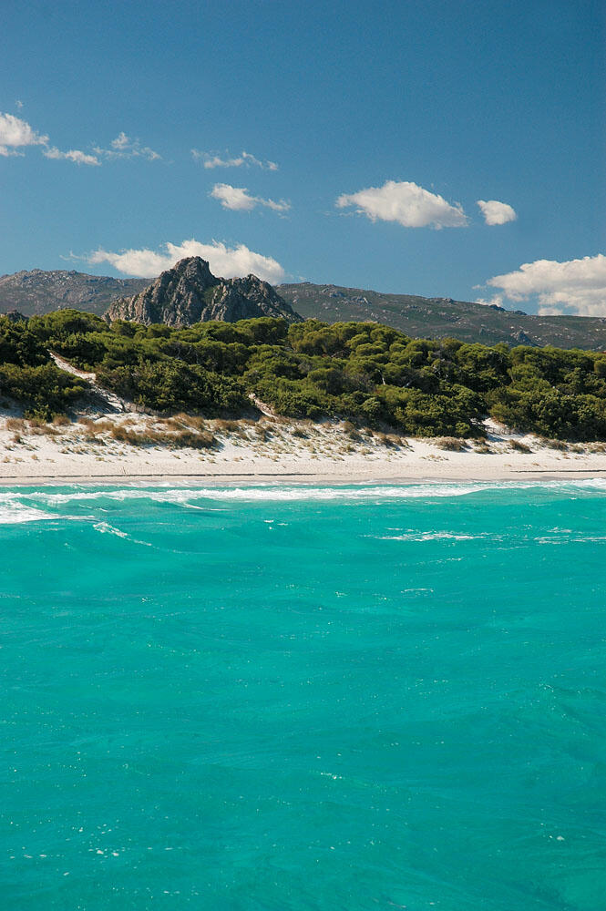
The waters were amazing, despite the churning of the seabed by the waves, while the all-white sandy beach that stretched out over a large area and the bushy dunes further behind gave you the impression that you were in some distant tropical paradise.
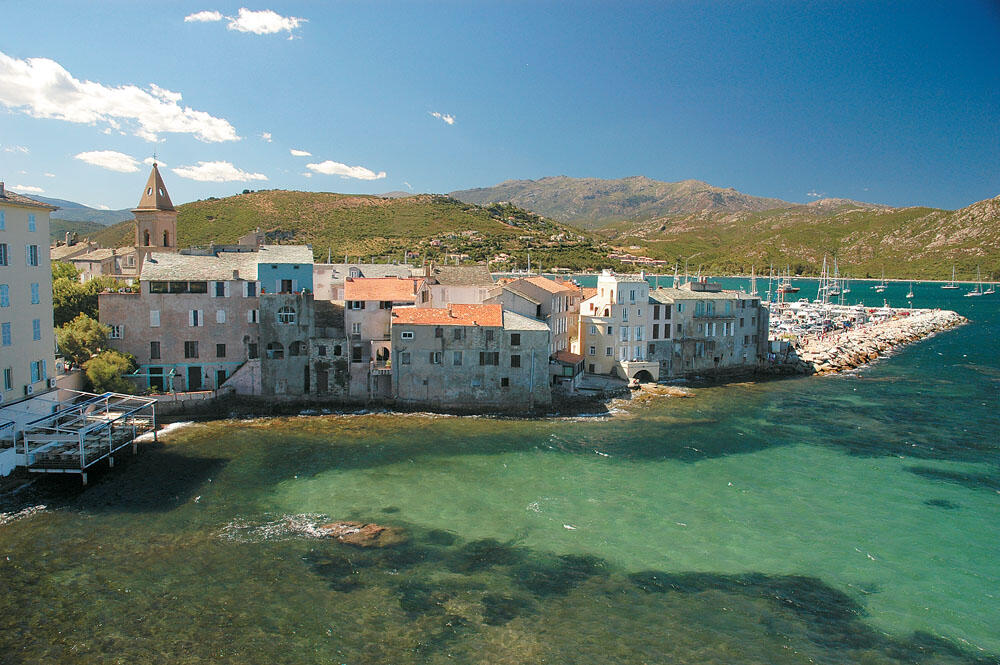
Chased by the weather, we slowly entered the large bay of Saint Florent, where the swell was noticeably lower. Our bow marked the eastern end of the vast beach of la Roya, which stretches for two kilometers and occupies the entire mouth of the bay. The small town of Saint Florent is built there, along its very large marina, which accommodates hundreds of yachts. Entering the port, we pulled towards the old and imposing buildings, where it seemed that the center of this sea-state was located. We were lucky enough to see yet another wonderful old city, which even seemed special and certainly completely different from what we had encountered so far. The gray color of several houses at a time and the faded earth colors of the rest in a row, as well as the impressive bell tower of Santa Maria Assunta that stands imposingly between their roofs, give us a first wonderful image of this place that fascinates you from the very first glance. Between the prows of the boats and the long corridors of the marina, the small town of Saint Florent, built at sea level, looks like a floating state that immediately reflects its long-standing glory. It is a very pleasant city, which is a very popular destination and attracts a lot of people every summer. It is also an ideal place, which we can use as a base for our tours of wonderful neighboring areas, as well as some of the most beautiful beaches of Corsica that are nearby.
We squeezed the inflatable between the characteristic Corsican boats and went out to the quay. Wandering through its alleys, we passed behind the Cathedral of Santa Maria assunta, which was built in the 12th century under the rule of the Pisans.
There is also the large square surrounded by many shops and bars. Heading north, in a few minutes we reached the castle built by the Genoese in the 15th century.
From up here the view is excellent, and of course the old houses that are wet from the sea and are obviously eroded by the oil, make up one of the most picturesque images of the whole of Corsica. Continuing our short wander, we headed to the east of the marina, where the Aliso River empties, and reached the iron bridge that leads to la Roya beach. We didn't continue, however, because it was already 14.00 and our thoughts were traveling out there, on the open sea... We had to pass Cape Corse by all means, because our days in Corsica were now limited and we still had a lot to do .
Climbing Cape Corse
Before long we were leaving the marina and the wind was "screaming", but we could not afford to postpone our sailing. we shoved into our already white, salt-white, nicherades, and prepared to sail around the Cape Corse peninsula. It is a narrow strip of land, 20 nautical miles long and with an average width of 6 nautical miles, resembling a long finger that rises from the north-eastern tip of Corsica, enters the Ligurian Sea and points towards the Gulf of Genoa.
Throughout the peninsula we meet many of the stone towers built by the Genoese to protect it from Saracen raids, while very characteristic and isolated are the small fishing villages and small mountain communities, which are built on the slopes of the steep hills. We sailed from a distance on the western side of the Cape Corse peninsula, which is very impressive and characterized by steep coasts that descend spectacularly into the sea.
We kept a northerly course and the farther we got from Saint Florent Bay, the rougher the sea. The weather initially found us in the band and after the first few miles we had it to the left.
The waves kept growing, and we, perfectly attuned to their own rhythm, looked in wonder behind their huge ridges, which disappeared from our field of vision even whole villages, built very high on the slopes of the imposing and precipitous coasts.
The waves kept growing, and we, perfectly attuned to their own rhythm, looked in wonder behind their huge ridges, which disappeared from our field of vision even whole villages, built very high on the slopes of the imposing and precipitous coasts. It was evident that these waves traveled for many miles, without any land to obstruct their course, with the result that they grew unhindered and reached incredible heights that surprised and bewildered even the most experienced skippers. And really, everything we've faced so far has been nothing more than small wrinkles in the face of this giant wave sweeping everything in its path.
The wind may have been breaking the anemometers and the huge waves made us feel completely "insignificant", but the bright sun and the wonderful colors all around filled us with an indescribable euphoria. Of course, our commitment was universal and we calculated each wave which, fortunately, developed with absolute periodicity. Just for a moment we tried to exchange two words and we paid for it with a strong jolt, which threw us several meters further, filling the blanket with "living" sea. We drifted for a while and now we waited patiently for the pumps to empty the water.
We insisted on keeping the inflatable away from the shore, avoiding the giant rip currents that were sure to form close to shore, and we didn't want to get stuck in between them under any circumstances. Traveling through the wreckage for more than an hour, we were slowly approaching the famous Cape Corse. The image of the lighthouse at the top of the steep cliff, several dozens of meters above sea level, will remain unforgettable. When we were in the chaotic gullies we lost sight of the lighthouse, but even when we managed to hold on to the crests of the huge waves we were dumbfounded observing how the advancing wave covered it and disappeared from our visual horizon.
Hooking Cape Corse, we crossed its northern side, which extends for a distance of 6 nautical miles. The giant waves were now overwhelming us. Turning our gaze back and seeing whole mountains of sea chasing us, for a moment we were bewildered...

The powerful motor, however, hanging on the transom of the inflatable allowed us to be in control and avoid mishaps. The large diameter propeller comfortably gave us the required thrust we needed to climb the backs of the waves at low rpm, while its short pitch gave us the explosiveness that in many cases was a lifesaver, especially when we encountered some unruly waves and a just a little push of the lever to avoid them. We felt completely justified with the choice of this particular propeller, while the Shearwater really "galloped", regardless of the height of the waves.
After all, its stern travel is a dream, and it is definitely one of its strong points. We preferred to pass through the channel, one nautical mile wide, which forms between the cape and the islet of Giraglia.
The waters in there are quite shallow, but they do not hide any dangers for passing boats.
Opposite the islet of Giraglia, in about the middle of the northern side of the peninsula, is the fishing shelter of the small settlement of Barcaggio. We passed quite close to it - as far as the visible waves allowed us - and observed this small place that really seemed to be at the edge of the world. A very lonely and isolated corner of the Mediterranean, whose image alone soothed our souls. It looked like a little niche of comfort and safety, in the complete abandonment of the sea. We really wanted to get closer and enter her little harbor, but the massive waves didn't leave us any such leeway.
Going East
We thus continued our course, and it was only when we began to round the north-east end of the peninsula that the waves gradually began to lose their incredible bulk, as the long and narrow peninsula of Cape Corse now sheltered us from the westerly weather. But before we had time to enjoy it, we were greeted by the scary spiders! We passed the Finocchiarola islets wide open and then turned inland, cruising at high speed in the short but devilish swell. Our long lashing through the craters was to end a mile and a half below, where Macinaggio is.
The large marina of Macinaggio offers the best mooring in the whole of Cape Corse and is an excellent retreat. With many shops along the marina, toilets, cafes, restaurants and the possibility of refueling, it looked like an oasis that ended the wild and inhospitable landscape we had encountered so far. From the northern side of the marina, where its entrance is located, begins the wide Tamarone beach, with wonderful green waters protected from the western weather, which is certainly one of the most beautiful beaches in the wider area.
However, there were too many boats moored in Arodo, so we decided to head a little further down, to the Cove de Meria. We got excited and immediately stretched out on the inflatable deckchairs, with a strong need for a few moments of rest. Across the island, the eastern side is gentler and more welcoming, in stark contrast to the rugged and spectacular coastlines of the western side. The sea on the eastern coast is equally welcoming, since the Corsican massif protects it from the west-northwest winds that usually blow in the summer months. Thus, sailing the entire eastern coastline of Corsica is an incredible cruise in calm waters, with no unpleasant surprises.
Destination Bastia
We still needed 14 nautical miles to reach Bastia, located on the eastern side of the neck of the Cape Corse peninsula. This historic city was one of the main destinations of our trip that could not be overlooked, since it was the old capital of the island and remains a very authentic and lively city. Even today it is the most important commercial port and financial center of Corsica.
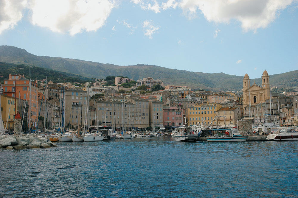
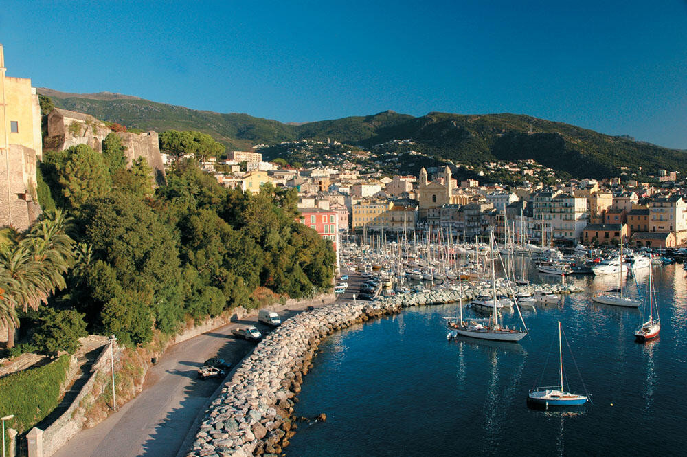
Four miles before Bastia, the scenery began to beautify, with deep gorges dividing the high green hills, on the slopes of which are sheltered very small and pretty settlements. We left the huge Toga marina on our right and continued towards the commercial port. Directly opposite its entrance are two magnificent stone lighthouses demarcating its small bow. We slowly entered the old port, clearly fascinated by the unique images our eyes beheld.
After a few meters, the bow of the inflatable came to rest in front of the imposing church of Agios Ioannis the Baptist which dominates the center of the old port, with its two distinctive bell towers standing tall and standing out from the roofs of the neighboring buildings. And while the old harbor is shaped like a horseshoe, when you are in its center you have the impression that you are in the center of a perfect circle, with the only opening being the point of its mouth. Within this circle are crowded the multi-storey buildings with stone roofs, making up one of the most picturesque neighborhoods of the entire Mediterranean.
We were so enchanted, that we did everything to find a place to spend the night in the heart of this wonderful harbor. Crowding from local boats and sailboats is heavy, since almost all berths are private. After fueling up, we managed - after constant contacts with the port authority - to find a place for two nights, which belonged to a Corsican who had taken his boat out for maintenance.
Delighted we tied up in his place, and, with the sun in his west, prepared for our departure. We preferred not to wander around the town, since dusk had overtaken us, so we decided to stroll along the waterfront of the old harbor to enjoy it as much as we could.
The lights slowly started to come on and the beach restaurants to fill up with people.
Everything looked magical and a fairytale atmosphere enveloped everything around, while the sounds from the various small music bands complemented very nicely one of the most beautiful evenings of our trip.
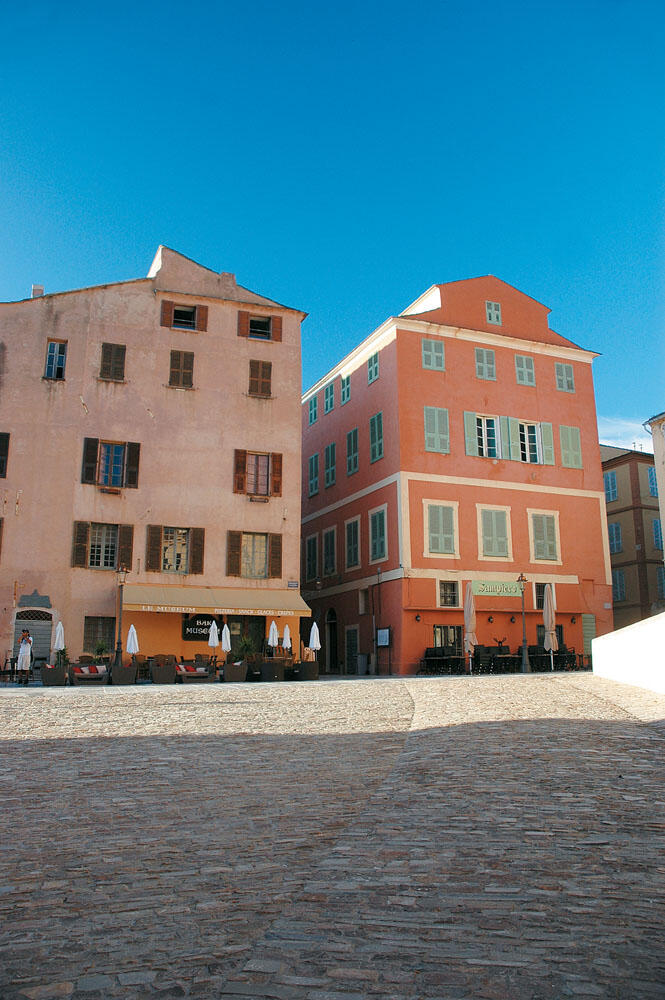
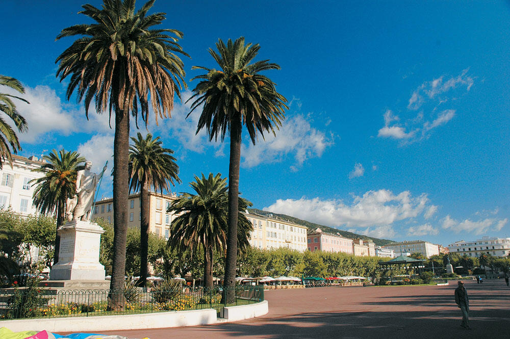
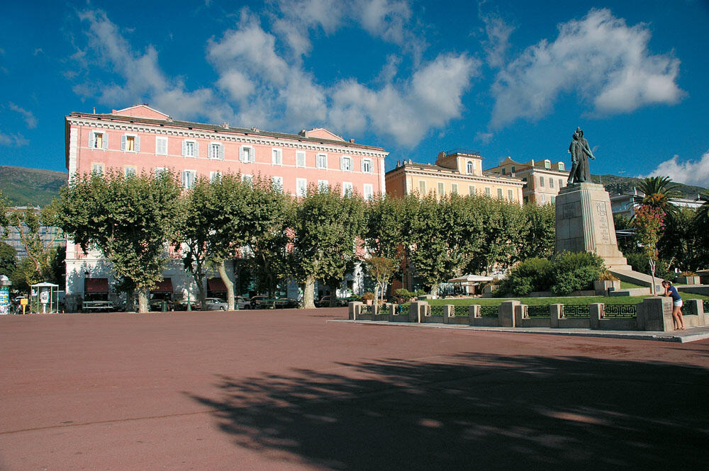
The next day we went out to the southern quay of the old port, at the end of which ends the low hill where the Romieu Gardens are. We climbed the steps and walked to the edge of it where is the beautiful lighthouse which, with its red light, marks the left end of the bow of the old port. For quite some time we stayed admiring the wonderful view under the shadow of the Acropolis, which together with the old port are the most important attractions of Bastia, as well as the large, wonderful square of Agios Nikolaos. A real gem for Bastia, with the five-storey attached buildings of the 19th century, in soft earth colors, built along its long side.
...keep Ribbing!