Samothrace Island
Ammouliani Island – Islets of Drenia
Samothrace Island
Ammouliani Island – Islets of Drenia
Limnos Island
There are few things that are so exciting and so liberating, as the time you are travelling your own course is. And it may be the only thing that as many times as you repeat it, it will always be the same exciting. I was watching the engraved sea and the temporary passageway that the propeller was creating...
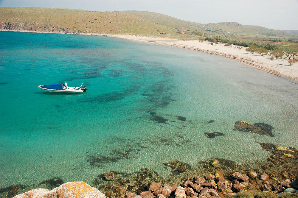
The north winds that raged across the Aegean for three consecutive days stopped, leaving a sweet sea in their wake, a constant companion for about 35 nautical miles. We were well out to sea when the sun began to lean on our stern, descending alongside the imposing figure of Athos.
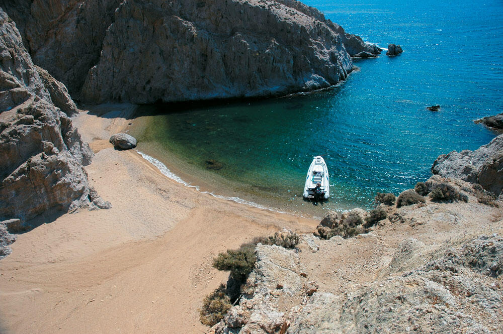
We shifted every little while the wheel, trying to capture some of the magic of the purple colored horizon. I sat in the front seat, with my back to the bow, and took off my nickerada. I lit a cigarette, my eyes gazing abstractly at the sea, rather bewildered by the unlimited freedom. I wasn't looking for anything in particular, and with my mind traveling without restriction. they reflect on how many times we've traveled this particular path, and yet, none of the magic of the first time is lost. Few things are as exhilarating and as liberating as the moment you travel your rutted course, and perhaps the only thing that, no matter how many times it is repeated, is just as thrilling, I watched the rutted sea and the temporary runway opened by the propeller , while a few meters further back the incoming waves made sure to quickly disappear every trace left by our passage.
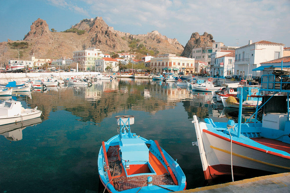
A vast crimson lake now stretched across our bow. while in the background the houses of Myrina began to be clearly seen with the first lights beginning to open, illuminating the large harbor, passing close by the imposing rock, on the top of which dominates an old castle, we slowly entered the large bay and headed. towards the old harbor located on its northern side, next to the long sandy beach. We carefully passed its narrow entrance and holed up in the only place available, among the colorful fishing boats.
The conversation was well on fire, and the glasses followed one another, until our strength failed us and we retired to sleep.
Sightseeing
- The Byzantine castle in Myrina, with the unlimited view towards the hinterland and the sea, as well as the free deers that live in and around the castle.
- The Archaeological and folklore museum, as well as the Cathedral of Saint Trinity.
- The ruins of the ancient Volcano and the sanctuary of Kaveri on the northern shores of the island.
- The prehistoric settlement of Poliochni, perhaps the oldest city of the Aegean, near the harbor of the village of Kaminia.
- The Pahies Ammoudies, large sand dunes that end in the sea, an unprecedented sight by the standards of the Aegean
- The small waterfalls of Katsaitis
- The rocky uniquely beautiful formations, in Fanaraki.
- The church of Panagia Kakaviotissa. built in the hollow of the rocks.
From here, the small town of Myrina can be clearly seen that spreads out behind the large rock of the castle, which divides it into two bays: The Romeiko. which is on the north side, and Turkikos on the south. Romeikos Gialos, where the rich families of the island first settled, is a long sandy beach, one of the most beautiful on the island. The beach road that runs along it, with its row of shops and old mansions, gathers the most people. The late afternoon, when the sun approaches its west, is the best time to visit the Roman beach and enjoy the wonderful sunset and if the atmosphere is clear, the peak of Athos, located 34 N.M. further west.
On the Turkish shore, there is the port where the ships catch, but also the old port on its northern side, next to the long sandy beach.
Walking towards the east side of the castle, the view towards the sea is magnificent. Looking south. at the top of the southern slope of the Turkish gulf, dominates the church of Ag. Nikolaou, while a little further down you can clearly see the Diavates islets and in the background Ag. Efstratios at 7 p.m. Searching for some time inside the castle, we finally unearthed the now famous deer, which were hidden in groups in the grass under the dense shade of the trees. Permanent residents of the castle for many years, they are now an integral part of it and one of the most beautiful "sights" of Myrina.
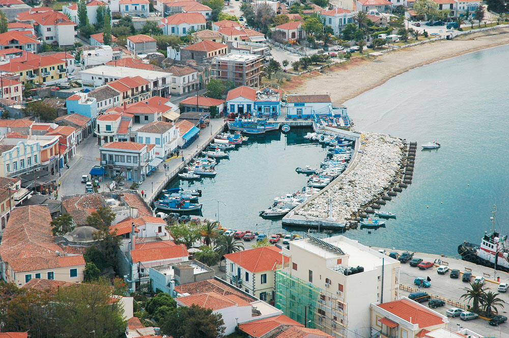
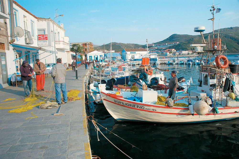
Myrina, the capital of the island for many years, is the port that connects Lemnos with the rest of Greece. Most of the island's inhabitants are here, reaching 6,000 souls.
Limnos, with an area of 475 sq.km. is one of the largest islands of the Aegean, with a strongly lacy coastline that in many places forms large bays and natural harbors protected from the north winds. It has many beaches, small and long stretches of sand, cosmopolitan or deserted coasts, able to satisfy our every desire. Slowly shedding the stigma that accompanied it for many years, as a large dry island and a place of unfavorable transition for the soldiers, it receives thousands of visitors every summer and despite its touristic development, it maintains its own unique and special character. Now famous for its wines, honey and its famous "basket", it offers the visitor local delicacies, while it is also famous for the fresh fish that fishermen still bring to the small port from the rich surrounding fishing grounds.
There are several dangerous spots in Lemnos and they need special attention.
- On the western side, avoid passing between the Diavates islets, while a little further down, at the northern end of Platy Bay (Β39-51-20 Α25-03-16) there is a small skopelos that protrudes just a few centimeters from the sea surface and surrounded by dangerous reefs.
- On the south side, there is a very dangerous shoal a few meters before Pateli, while special care is needed if you move in the shallows in the Gulf of Moudros. At the western end of the bay, pass clear of the islet of Button, for its inner side is full of shoals.
- On the north side of the island, the wider area of Ag. Ermolaou is scattered with drylands, while in the small port of Kotsina the waters are very shallow, approach only at the pier that cuts off the Gregos.
- Generally, the eastern side of Lemnos, although initially frightening with its shallow waters, does not present any dangerous point as long as we sail a little offshore.
WEST COASTS
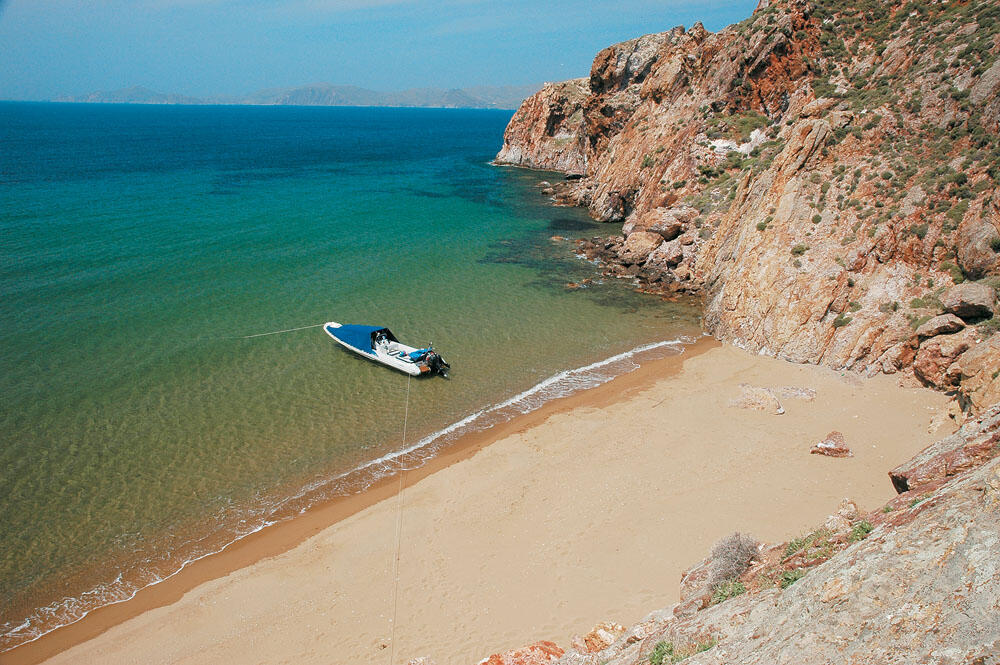
The entire western coastline of Lemnos. rocky and precipitous for the most part. it is scattered with small and large sandy beaches. It extends over a distance of 10 nautical miles, from Cape Tigani in the south to Cape Mourzeflo in the north, and hosts some of the most beautiful beaches of the island.
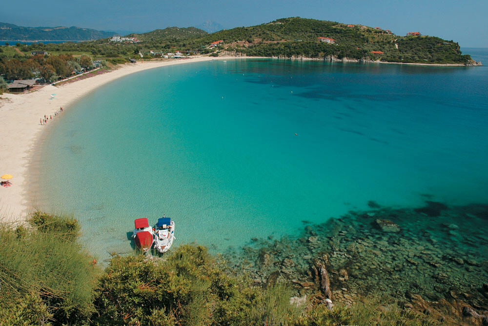
In the southernmost bay on the west side, is the famous Platy beach, which gathers a lot of people since it is very close to Myrina. With several trees along the coast, beautiful rooms for rent and tavernas serving fresh fish, it is a magnet for many visitors. On the south side of the bay, there is a very small harbor that is suffocating with small boats. But we can safely moor at the dock located at its entrance or even near the beach, since the entire bay provides very good protection from the north winds. Sailing in a northerly direction, in the next bay we come across is the port of Myrina with its imposing castle on top of the hill. Crossing the small arch of the castle, we enter the large bay which hosts two beautiful and long sandy beaches with crystal clear waters. The Roman beach, with the tavernas and cafes in a row, and the Shallow Waters further north. These beaches are crowded with people since they can be easily reached by walking a few minutes from the port. On the northern side of the large bay, there is a very small harbor with shallow water, into which a wide concrete slip ends. However, its space is limited and it will hardly fit even a small boat.
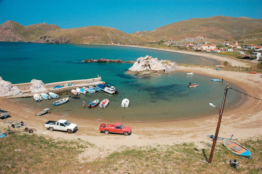
Passing Cape Petassos, we enter the largest and most open bay on the western side of the island. There are two very large beaches here: Avlonas further south and Ai Giannis a little further up. On the coast of Ai Giannis, there is a very beautiful and well-formed harbor that accommodates the boats of the locals as well as the boats of summer visitors. It is a small natural cove lined with fine sand, protected by a large rock at its northern end and by a concrete jetty of a few meters at its southern end. Very quiet place, with two small taverns just beyond the harbor and several rooms for rent. Of course, we can spend the night in the inflatable, enjoying the excellent sunset, but we need to be careful when the north wind turns into a master. Going up towards Mourtzeflos, there are several more small and deserted beaches, with the Morassiti sandy beach prominent. which lies in a small cove, about two miles before the north-west lighthouse.
THE NORTH AND EAST COASTS
At dusk, we returned for the night to the port of An Yiannis and tied up next to the small boats. We took out the chairs and the small table in the concrete dock. where we enjoyed our evening meal, accompanied by the wonderful lake wine. We were quite tired and soon retired under the bow awning.
Early in the morning, we were woken up by the speeches of the fishermen entering the harbor with their boats. We gathered around their long-line basins and gazed at their catch, but it was not good. "Year after year the decrease in catches is evident" they told us, looking quite disappointed. After drinking our morning coffee together, we greeted them and set sail for Cape Mourtzeflo.
On the western side of Bournia, we find the long sandy beach of Ag. Ermolaou with the small harbor at the end. Our approach is very cautious, as the whole area is full of shallow and dangerous drylands. At the mouth of the Gulf of Bournia, is Kotsinas, an old and abandoned fishing village, with two tavernas on the waterfront. It has a safe harbor. which in the summer shows a lot of traffic. We sat down at the "Mourayo" tavern, which plays beautiful music, for ouzo and some rest, enjoying the peace of this place. A bit higher. on the eastern side of Bournia Bay, we find Tigani Cove. Here is the archaeological site of Ifaistia, which was the capital of the island until the 12th century. A few meters beyond the northern bay of Tigani bay, on the steep coast, we find the sanctuary of Kaveri, where the famous Kaveri mysteries were celebrated.
Very soon we reached the northeastern tip of the island. A narrow strip of land ends at Cape Plaka where the imposing lighthouse of the same name is located. On the western side of this small peninsula, there is the small port of the village, which is built two kilometers inland. Cruising the cape, with the mountains of Imbros clearly visible on the horizon, we began to descend the eastern shores of the island.
If we exclude the short stop we made at the small harbor of the village of Kaminia. to visit the ruins of Poliochni, perhaps the oldest settlement in Europe, we soon sailed along the eastern shores of Lemnos, which is full of vast sandy beaches which are not suitable for our kind of boat holiday.
Refueling
- To get a suppliy of fuel and ice, prefer Myrina, where gas stations now have 300-liter containers for transporting fuel (Tel. 22540-25100). If you are in the port of Moudros, there is the possibility of refueling on ice, but for fuel you have to have concrete and walk to the nearest gas station located on the main road, at a distance of about five hundred meters.
SOUTH COASTS
With the sun leaning towards its west, we entered the bay of Moudros, one of the largest natural ports of the Aegean, with a rich history. Passing between the signalmen who direct the boats, protecting them from the shoals, we slowly entered the narrow entrance of the second port of Lemnos, located on the eastern side of the cove of the same name. It is a fairly large and beautiful port, completely safe in all weathers, with excellent quietness. Even in the summer months, we will easily find a place to tie up. Many fishing boats take refuge here, going out every day to fish. In front of the harbor there is a children's playground, behind which the two taverns undertake to satisfy our culinary desires, in a very friendly and quiet environment.
We chose the port of Moudros as a starting point for our wanderings on the southern coasts of the island, which are of great interest. The large bays with their wonderful sandy beaches and natural harbors, where we can spend the night without fear, promise enjoyable moments.
Early in the morning, after the necessary coffee, we visited two of the most beautiful beaches of Lemnos, located in the wider area of the Gulf of Moudros. Fanaraki, which is located just after Cape Sograda, a small beach that gathers a lot of people, and Havouli, which is located before Cape Malathrio and is a beautiful stretch of sand with wonderful waters.
We were basking on the rocks of the southern side of the Havouli bay and were enjoying the magnificent scenery, when we noticed that an inflatable awning with a gray bow was coming towards us. When it got close enough to us, we realized it was the Coast Guard inflatable. He passed us, and after the necessary inspection by the two harbor guards on board the inflatable, we chatted for a few minutes, but long enough to see with great pleasure their excellent behavior. Politely, keeping the balance between authority and human behavior very well, they informed us that they patrol the island every day, while from our brief conversation it was clear that they knew their boat and its capabilities very well. I don't remember ever meeting such well-trained porters, who actually knew the sea and kept their boat in very good condition, contrary to what we are used to seeing. An example for their colleagues to follow and an honor for the Coast Guard to have such people in its ranks.
After this unexpected, but hopeful encounter, we headed for Koumbi islet, the western end of Moudros Bay. We passed in the open, owing to the numerous reefs that lie in between, and after a short course we approached a ship which, smashed on the rocky shores by the fury of the south, is now a sight to behold in the passage of the seas.
We rounded Cape Stavros, and slowly and exploratory entered Kontias Bay. At the beginning of the bay and on its eastern side, is probably the most beautiful beach of Lemnos. The Reds, as the golden sandy beach is called, where the imposing reddish rocks that drop vertically to the coast end. Despite the small waves, we could not resist the temptation of this enchanting beach and without a second thought, we weighed anchor. We spent several hours swimming in the beautiful waters, observing the beautiful rock formations.
Moving into the bay, we come across several large sandy beaches, but the waters gradually lose their clarity. At the mouth of Kontia bay, lies Diapori, a natural harbor safe in the north. Opposite Diapori, on the western side of Kontia bay, is the port of the same name, which is suffocatingly full of local boats. Leaving behind us the bay of Ag. Pavlou, in which there are several sandy beaches, we head to the small peninsula of Asirokavos. On its eastern side is Pateli, the port of Thanos village. It is a small and pleasant port, which has recently been expanded and is now a very safe haven. Ideal for an overnight stay, when we move to the surrounding beaches. On the western side of Asirokavos, we find the wonderful sandy beach of Thanos with very clear and very shallow waters. Rounding the southwest cape of Lemnos, Cape Tigani, completing the circumnavigation of the island, we slowly entered Platys Bay, where we had planned to spend our last night.
With the first pleasure and with very pleasant memories to accompany us, especially from the friendly people of Limni but also from the local fishermen who always made it easy for us to find a place, in whatever port we were, we left Lemnos behind us... as our bow has already started looking for new destinations...
Marine information
- The start of the monsoons in the summer months is marked by the sudden appearance of northeasterly winds, which reach or even exceed 7 Beaufort, and last without stopping for a week or two. Then their intensity and duration are more predictable, freshening up as the sun rises above the horizon, but they rarely exceed 5 to 6 Beaufort and usually last for a single day. Shortly after noon, they reach their maximum value. whereupon they turn in clear tramuntana to slowly become north-westerly, whereupon they break completely in the afternoon, leaving the sea to be calm. This cycle happens daily, so we are almost certain to have good seas in the early morning or late afternoon. Sometimes, however, when the meltemi does not turn into a maistro, the weather lasts even in the evening, to continue more fiercely the next day. We must know that even 5 Beaufort is very difficult weather and will trouble us enough, because the strong currents that prevail around the sea area of Lemnos, always have the opposite direction to the local winds, creating irregular waves that are difficult to travel.
- At the northern end of the entrance to the port of Myrina, the construction of a jetty about three hundred meters long is already underway, which will provide absolute protection from the westerly winds. The first blocks have begun to fall, the number of which is expected to exceed 10,000. At present caution is needed in our approach. since some blocks reach the surface of the sea, the area is however adequately marked.
- Inside the bay of Myrina and directly opposite where the boat of the line catches, there is a fairly large slip. capable of launching large boats as well.
- Of greater interest are the western and southern coasts of Lemnos, where the most beautiful beaches are located. Kokkina and Havouli are sandy beaches that will enchant even the most demanding visitor.
- The circumnavigation of the island reaches 105 nautical miles, so good planning is needed in terms of the places we will use as anchorages. The port of Moudros and Pateli (B39-50-33 A25-05-22) for even more peace, are ideal for an overnight stay when moving to the southern coasts. On the western coasts, prefer the bay of Platy or the small harbor of Ai Giannis (B39-55-50 A25-03-93), which is affected only by westerly winds. On the northern coasts, prefer the port of Kotsina. while if you want to spend the night on the eastern side of the island, the northern side of Keros is the best choice.
Port Authority: 22.225
Municipality of Myrina: 22.208
Police: 22.200
Health centre : 22.222 και 23.333
Car rentals: 23.280 και 24.476
Taxi station: 23.033 και 23.043
...keep Ribbing!