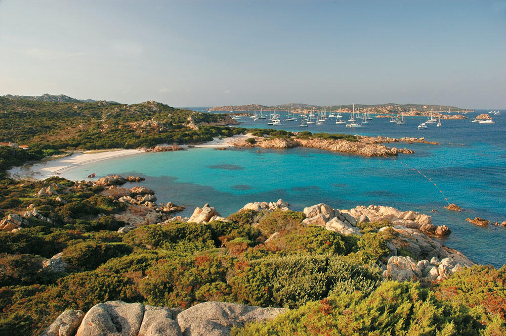
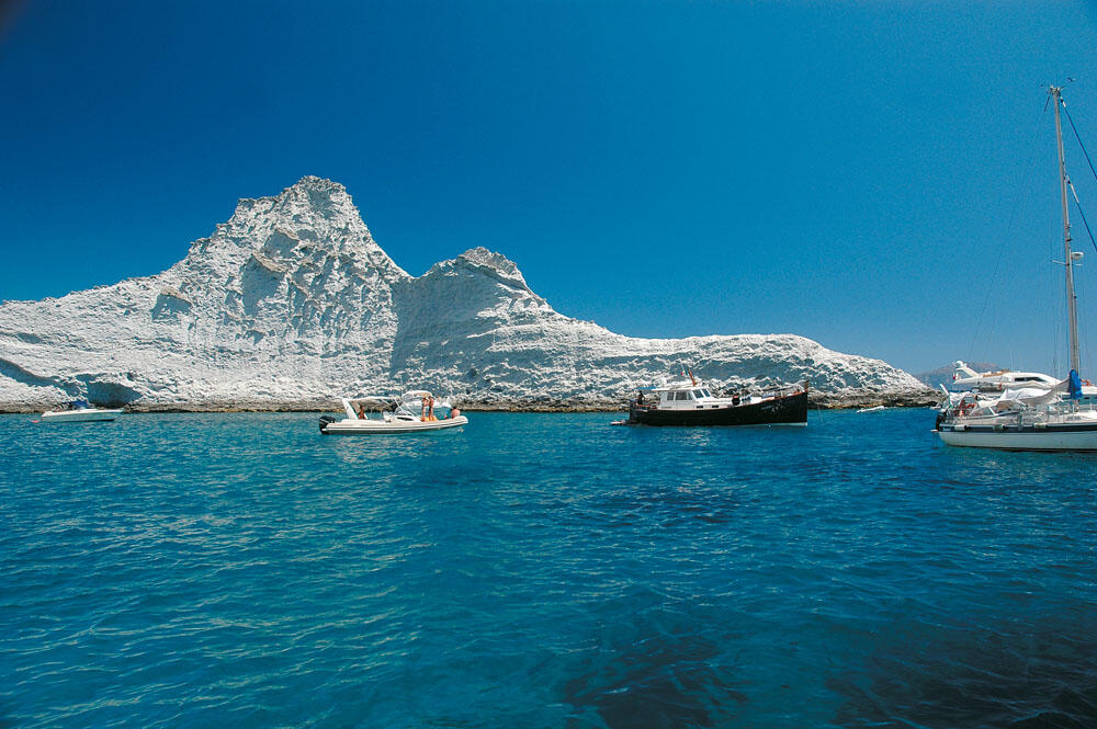
Approaching the Archipelago of Maddalena at rough sea
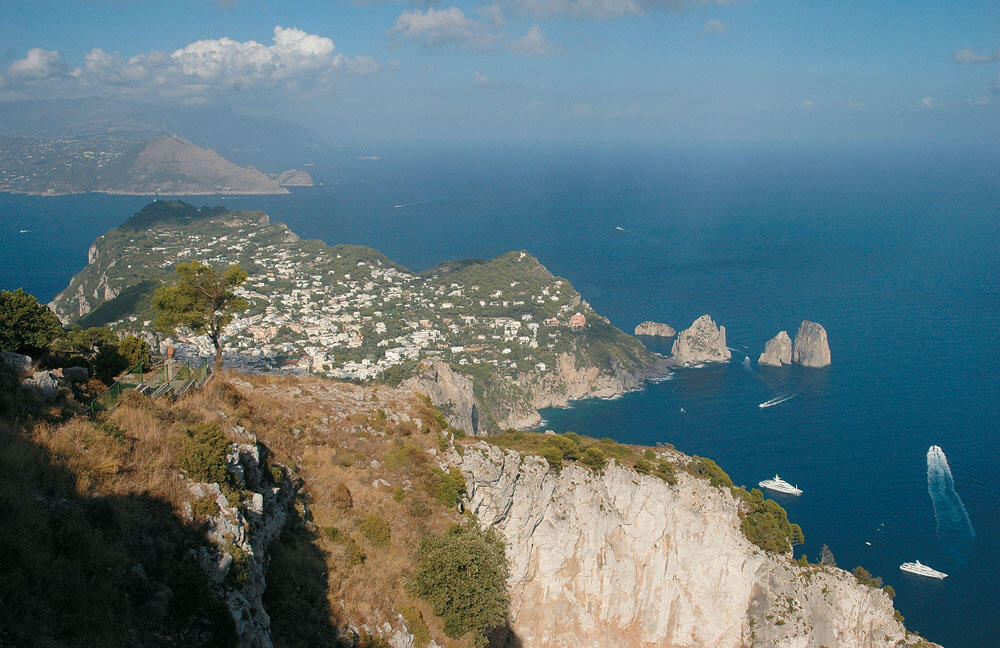
The island of Capri
Approaching the Archipelago of Maddalena at rough sea
The island of Capri
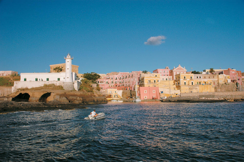
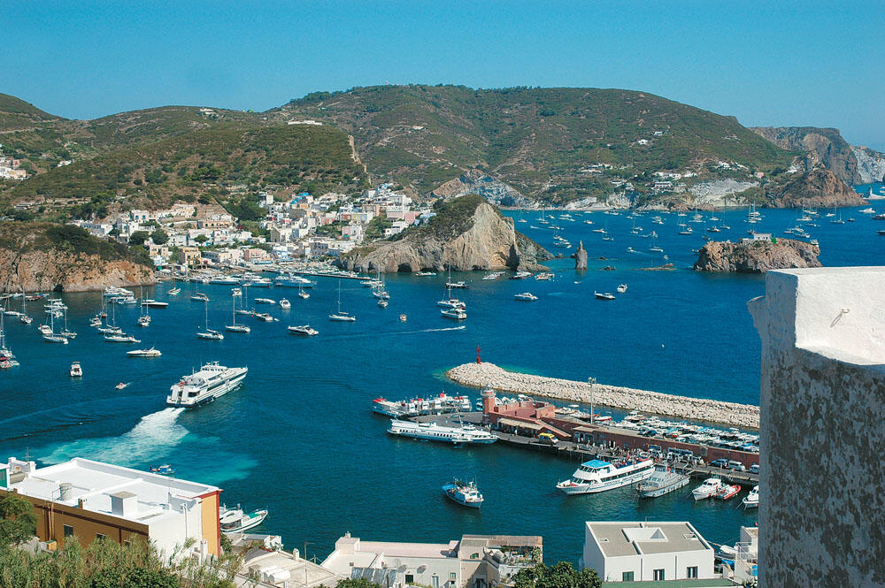
Pontine islands
The lights of marina Piccola had not turned off yet, and we’ve already been travelling at low speed beneath the steep cliffs of the south side of Capri.
We soon arrived near the lighthouse of Punta Carena, where we stood for a while in order to plan our new course. Covering with a towel the electronic equipment of cockpit so as not to ‘blind’ us and sucking the last sips of coffee, we were watching very carefully the sea around us.
It was half past five in the morning and the silent waves found us wide open. We knew, however, that the wind would take a long time to turn to pointe, and this swell did not worry us at all.
We charted our course and the bow turned to 293°. Our destination was the group of Pontine islets, and more specifically the Ventotene islet from which we were separated by 40 nautical miles. We kept strictly to our pledge to cruise at less than 15 knots, patiently waiting for her to carve.
Our silence was characteristic, an unmistakable sign of our total fixation on the dark horizon. Everyone was investigating their own side, although we knew that there were no dangerous spots in the wider sea area. The chance, however, of crossing some buoy or other object, though slight, did not allow us to be complacent for a moment.
I don't know what it is exactly that enchants us in the night sailing, but I am absolutely sure that we were once again experiencing unreal moments. Feelings and images from an alien world, as if we were on some secret mission, trying to go unnoticed in the absolute peace that covered everything around us.
Only the sound of the sea could be heard as the inflatable floated softly, following the waves. As our stern dragged through the dark waves, the sea whitened behind us, momentarily losing its smooth course to the south. And this very sound that the sea makes reaches our ears as the most seductive song of the Sirens.
At one point, as if by telepathy, we looked into eyes that seemed filled with an indescribable joy. I was holding the steering wheel firmly with my hands, when my gaze crossed the glimmer of the lighthouse of Ischia. At about seven o'clock we passed the south-west shores of the island of Ischia, which was half-way on our course.
Early in the morning
He had already carved, and slowly the whole horizon began to turn golden low. Our path was now brighter and we, more relaxed, turned our gaze around, enjoying the purple colors that began to paint every corner of the horizon.
And suddenly, as if our accumulated energy overflowed, and the lever was jerked forward. The whole inflatable came out of the water and "flew" from top to top, thus covering several nautical miles. Our faces shone and, completely happy, we rejoiced with all our senses in this otherworldly "world".
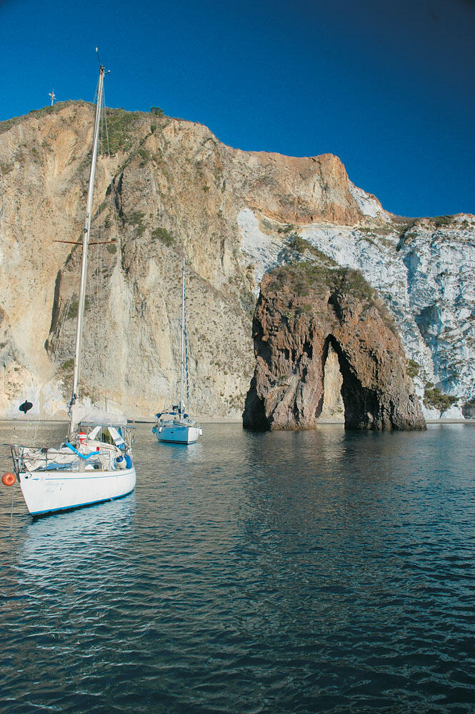
Leaving Ischia in our stern, we watched the sun rise behind her massif. In the distance, a little to the right of our bow, the long narrow low rock of the Ventotene islet, which belongs to the Pontine group of islands, began to be seen.
The Pontine Islands may be unknown to us, but not to the Italians, as they are very close to Rome and Naples, making it a major tourist destination, which in the summer months is literally flooded with yachts.
At a distance of only 55 nautical miles further north are the great marinas at the mouth of the Tiber River where the... Romans moored their ships. Without knowing anything about this group of islands, we chose it only because of its geographical position, as a way station on our way to Corsica and as a starting point for the Tyrrhenian crossing, since from here the distance to the opposite coasts of Sardinia and Corsica ranges from 160 - 170 nautical miles.
The Pontine Islands
The Pontine islands are located between 40° 47' and 40° 59' north latitude and 12° 50' and 13° 30' east longitude. They are six small islands, divided into two different clusters, which are about 20 nautical miles apart. The first cluster is located to the northwest and consists of the islets of Ponza, Palmarola, Zannone and Gavi, while the second is located to the southeast and consists of the islets of Ventotene and Santo Stefano.
The first group of islands is about 15 nautical miles from the nearest land on the west coast of Italy, while the second group is 25 nautical miles off the west coast and 35 nautical miles west of the Gulf of Napoli. The Pontine Islands, which constitute the eponymous archipelago of the Tyrrhenian Sea, are the result of volcanic activity and have been inhabited for thousands of years. The largest island of the complex is Ponza - from where its name comes - which together with the island of Ventotene are the only inhabited ones. After all, these two islets, as well as the uninhabited islet of Palmarola located further west of the complex, are the biggest attractions of the Pontine Islands. In the remaining three islands of the complex, which are very small and their perimeter varies from 1 to 2 nautical miles, there are no beaches, but they do not present any particular interest.
In the end, the Pontine Islands exceeded all our expectations and turned out to be a wonderful destination, with its own unique atmosphere and its own distinct color that cannot be found anywhere else in the Mediterranean. With particularly spectacular coasts, with wonderful beaches but also very beautiful settlements that take you back many centuries, they are without a doubt a very attractive travel destination that has given us images that the eye is not used to seeing.
On the islet of Ventotene
It is the largest of the south-eastern group of Pontine islands, and lies about a mile west of the second islet of the group, Santo Stefano. Since 1997, the marine area around the two islets has been declared a marine park. It is a long narrow and almost flat island, with a length of 1.5 nautical miles and a maximum width of no more than half a mile. It has a direction from northeast to southwest, gradually rising in its descent, to reach its highest peak at 139 meters high, at its southern end.
From the time of the Roman Empire until recently, the islet of Ventotene was a place of exile. Several members of imperial families have been "confined" here for various reasons. One of the most famous exiles was the only daughter of Augustus, Julia, who lived in the palace called Villa Giulia. Today, we can visit the ruins of the villa, which are one of the main attractions of the island, at its northern tip, Punta Eolo.
The islet of Ventotene currently has 700 permanent residents and in recent years has been an attraction for many visitors, mainly Italians. And of course, it is not the beaches of the island that attract people, but the unique architecture of the settlement that strongly transports us to the Roman era, the old Roman port and the wonderful quiet atmosphere that lingers everywhere, even in the middle of the summer season. It is also an excellent diving destination, with rich aquatic life, Roman wrecks and various ancient finds.
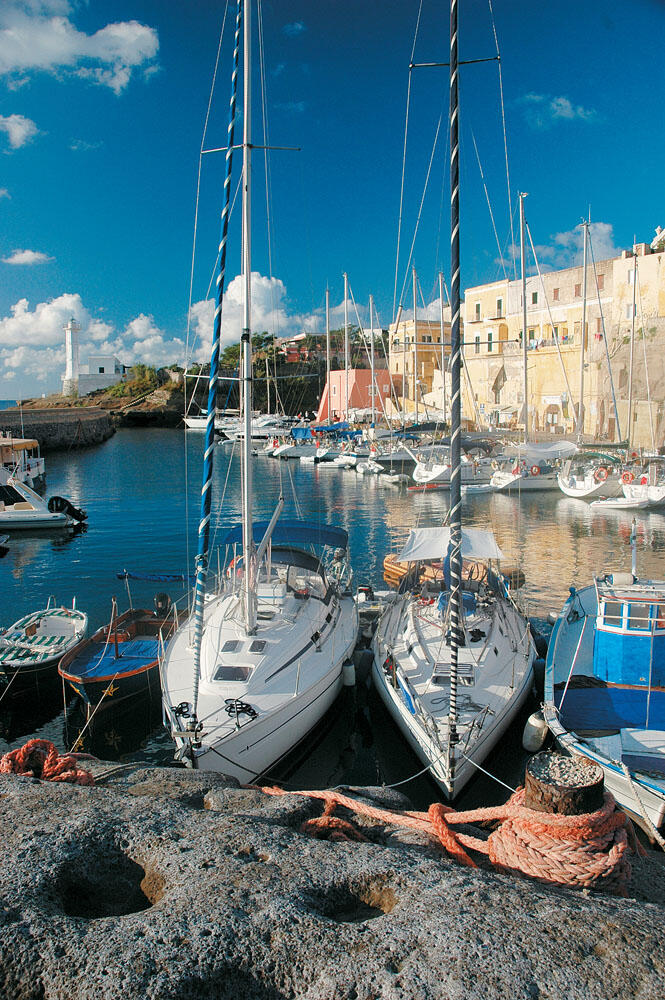
We passed very close to the north side of the islet of Santo Stefano, and our bow turned to the north-east end of the islet of Ventotene. There are the only village and the two ports of the island. The closer we got, the more attractive the image of the small settlement became, with the sweet colors of the morning bathing the old houses, giving a magical dimension to the whole place.
We arrived outside the very narrow mouth of the old port, at the left end of which the tall, all-white lighthouse dominates, and the camera literally caught fire.
The shutter was constantly opening and closing, trying to capture as much as possible of the beauty of this place, capturing unique, and above all, authentic images.
As our bow slowly entered the bow, the sight became more and more exciting. After a few meters, on our right and almost at an angle of 90°, begins the narrow fjord that runs parallel in front of the first houses of the settlement. After a northward course of about a hundred meters, this narrow fjord is cut off by a wide strip of land, behind which is the island's new port.
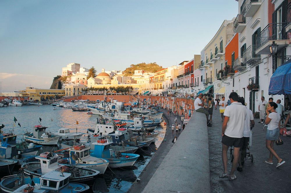
It is an artificial canal, which was made in ancient times, and is called Porto Romano. It is the old Roman port that remains exactly as it was in antiquity, being one of the most important attractions of the island and the only functioning ancient port in the entire Mediterranean. It is full of local fishing boats where, together with the wonderful old buildings painted in ocher, it is a fairytale picture. A truly enchanting seaside neighborhood, completely authentic, that vividly reflects its ancient history.
We pulled up in front of the concrete waterfront's only cafe and headed out for an invigorating espresso. We were alone in this wonderful place, as it was still very early and there was no traffic at all in the old port. We enjoyed the absolute peace of the place, while our gaze hungrily scanned every corner. This place was an unexpected surprise for us and we wanted to experience it with all our senses.
The two ports of the island
After quite some time, we got up and started for a short walk around the long, narrow old port. We climbed onto the breakwater that is built on top of the volcanic rock, and headed right across the waterfront. We were only a few meters above sea level when the sight became even more beautiful. The narrow channel and the boats moored in a row, at the foot of the black volcanic rock, lay just below our feet, and we now had a more panoramic view of this wonderful corner.
As if no time had passed since then, we had the feeling that at any moment the prow of some Roman galley would emerge from the narrow mouth, and come to tie to the two remaining carved stone crypts that still stand out on the inner side of the volcanic rock, which used to be the natural breakwater of the ancient port.
The ancient harbor is entirely artificial and 60,000 cubic meters of volcanic rock had to be removed to create it.
It is worth noticing that the inner side of the natural rock - which also constitutes the breakwater - is cut vertically, with a direction from south to north, offering protection from all weathers. Only the strong south-easterly winds bring a light breeze, but pose no danger at all to moored vessels.
Under the all-white lighthouse, located at the mouth of the harbor, you can clearly see the caves and underground arcades that communicate with each other, where the Romans had established a small industry for the production and preservation of fish.
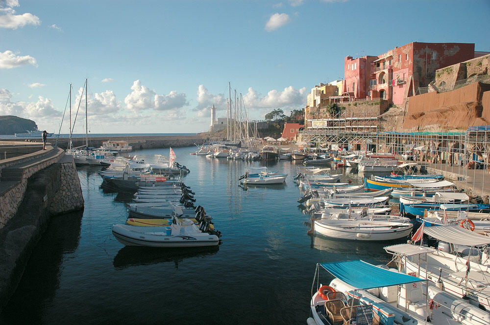
At the end of the old port, on its northern side, a wide strip of land is inserted, which practically separates it from the new large port, Porto Nuovo as it is typically called. It is located inside the large bay of Cala Rossano, and is protected by a massive and long breakwater, which cuts off the waves created by the easterly winds.
Its entrance faces north and is where liners, commercial and tourist boats dock.
Unlike the old port, which can accommodate only small boats, the new port is very spacious and on its southern side is the marina di Ventotene. It consists of two long floating platforms connected to each other forming an obtuse angle, where large pleasure boats are usually moored.
On the western side of the bay that houses the port, there is a long sandy beach filled with bathers, while a little further on is the gas station. Installed on excavated rock, it runs hoses down to the sea to service pleasure boats.
Inland
After our short walk to the new port, we returned again to the quayside of the Roman port, from where our tour through the village would begin...
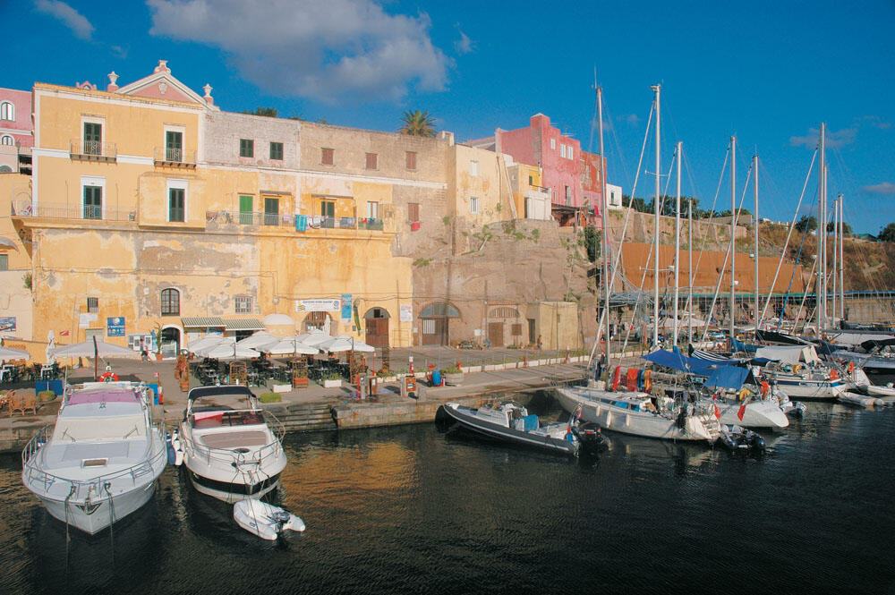
The sun had risen quite high, and the old port began to show activity with people. Some were taking their morning walk, while the shops next to the cafe - whose operational spaces are located inside the excavated volcanic rock - opened their large doors.
A well-organized diving center and a food warehouse are located next to the cafe, while the main person on the waterfront was the port manager, who tried to serve the few boats that were moored here.
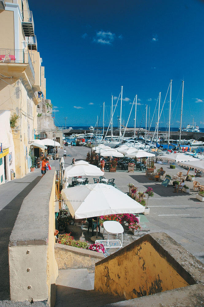
We took the wide cobbled path that starts from the quayside, which zig zags up and down to the first large square of the settlement, Piazza de Gasperi. Here the imposing church dominates, while a little further on there is a small cafe, which puts out its large umbrellas and small tables in the square. To the left of the square begins the narrow street Via Roma, which "runs" south and is full of small shops in a row.
Very soon we are led to the second large square, Piazza Castello. This is also the central square of the island, where the old impressive four-story building dominates, which, like a large square castle, is a reference point of the square.
It houses the Town Hall and the island's Museum, while the large square hosts all the summer events, as well as the film festival organized on the island. Surrounding the square are several shops, cafes and restaurants, in very beautiful and excellently maintained buildings.
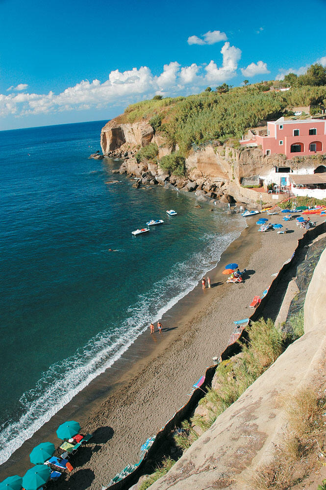
Proceeding to the eastern side of the square we were led to a narrow alley, which after a few meters brought us out to a wonderful balcony. Right under our feet stretched the only beach of the island, Cala Nave. Covered with black volcanic sand, next to the vertically cut rocks, it is without a doubt a particularly beautiful picture. It is located very close to the small Roman harbor, south of the white lighthouse of its bow.
We returned to the main square and wandered through the surrounding narrow streets. Everything was neat and clean, while the simple architectural lines of the houses - which are closely built -, as well as their intense colors dominated by ochre, pink and orange, make up a very beautiful environment.
Of course, what impressed us the most was the absence of people and the incredible silence that prevailed everywhere, even in the most central places. We very rarely met anyone walking in the alleys, and we had a strong feeling that we were in some very distant and forgotten place. On the other hand, judging by the boats that were moored in the two ports, we knew that there were certainly many visitors to the island. This absolute peace initially quite surprised us, since we had just arrived from bustling Capri.
However, it did not take long to seduce us and subject us to slow rhythms, which we so badly needed.
Returning to the small Roman harbor where we had temporarily tied the inflatable, we sat down at the waterfront cafe for another coffee, before setting off for the circumnavigation of the island.
We wanted this to be the last point from where we would say goodbye to the islet of Ventotene, and we wanted to collect as much beauty as possible from this unique sea neighborhood of the Roman port. A beauty that is certain to remain forever in our hearts, as one of the sweetest and above all most authentic corners of the entire Mediterranean.
As far as the islet of Santo Stefano
Filled with beautiful feelings, we slowly emerged from the narrow bow, our bow pointing north. We passed outside the new harbor and soon rounded the northern cape of Punta Eolo.
We were moving very close to the coast and at very low speed, since the perimeter of Ventotene Island does not exceed four nautical miles. We carefully passed between the dangerous shoals located a few tens of meters offshore from Punta Eolo, and began to descend the side of the island facing the maistro. With a fairly annoying headwind (the master did not exceed 4 Beauforts), we soon reached the south-eastern tip of the island, Capo dell' Arco.
This whole side of the island is characterized by the wild low volcanic rocks, which with their pitch-black appearance compose a quite dramatic picture, without of course the presence of a beach.
Turning to the south-eastern side of the island, with the landscape hardly changing, we arrived outside the beautiful sandy beach of Cala Nave.
Very close to the beach, the sea remained undulating, but we could not get too close because the protective buoys were spread far from the shore.
In the end, we were left to admire her from afar, we were also excited, just like dozens of other pleasure boats.
After relaxing for quite some time, swimming and wading more, we decided not to spend the night on the island and set sail for our next destination, since we had enough time until sunset. But first we flew a mile below, to see up close the "scarred" islet of Santo Stefano.
The prisons of Santo Stefano
In making the circuit of this round rock, the island of Santo Stefano, the circumference of which reaches only one nautical mile, our gaze was constantly fixed on its summit, since its shores present absolutely no interest.
So up there, a few meters above sea level, dominates the now deserted, imposing circular building of the old prison. A place of pain and sorrow for more than two centuries.
The imposing prisons on the dry rock were built in 1795 by the King of Naples, Ferdinand IV. All the prisoners who had a life sentence ended up here, while from time to time very important persons were "hosted". Characteristic was the inscription at the entrance of the prisons "here the justice of man ends and the justice of God begins".
Right below the desolate prisons, condemned for life to the enchanting bonds of the sea, we were again bent over the nautical chart charting our new, short this time, course...
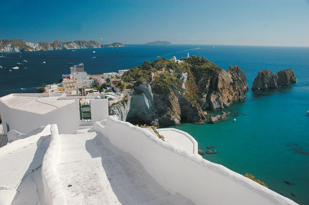
In the colorful Ponza
We were off the northern light of Ventotene Island and 22 nautical miles from Ponza, the largest and most popular of the Pontine Islands. Our prow turned north-west and marked her south-east part, where is the great bay which hosts her port. With the sea as our ally we quickly covered the short distance, and in the early afternoon we entered the busy port.
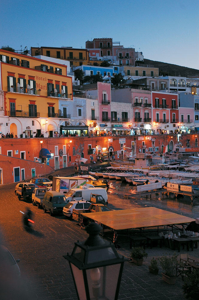
Of course, what stands out at first glance and keeps your eye fixed are the incredible colors of the old houses, which seem to be competing for which one will be more intense. An incredibly colorful settlement sprawls amphitheatrically on the slopes of the low volcanic hills, composing a very beautiful and particularly vivid picture, where the shades of red, ochre, blue and white are the protagonists.
After the necessary photos, our first concern was finding a place for the inflatable. Inside the bay, which has a circular shape, with its entrance facing northeast, beyond the harbor where there are no free berths for pleasure boats, there are eight floating platforms that have the role of small marinas. On the south side of the bay and next to the port are the two floating platforms of Ponzamare, between which there is also the only gas station. Suffocatingly full, with large main boats, they leave no room for finding a free place.
On the northern side of the bay there are two other floating platforms, which are also full of large boats. At the mouth of the bay, where the wide sandy beach is also located, there are still four floating platforms that accommodate smaller boats, mostly inflatable ones.
Everywhere it really becomes inseparable and it takes a lot of patience to find a free place. The problem, of course, was not our overnight stay - since we could anchor in the bay - but how we would go out for our little walks in the harbor and the small settlement, since we didn't have an auxiliary boat.
Finally, we turned towards the mouth of the cove where the inflatables were moored in parallel rows, close to each other. There we were greeted by the people who manage this side and after tying up the inflatable we were taken to the beach in a small plastic boat. After all, this is a popular way of anchoring and transporting crews throughout Italy.
Getting to know the Island
Very soon we were at the beautiful port, where many people crowded the cobbled coastal street. We had a strong feeling that we were in another era, and this is largely due to the old colorful houses that faithfully follow the traditional architecture of the island, and which, built one next to the other, look towards the port.
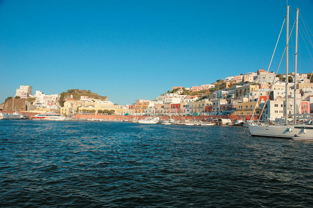
But the main element that makes the port stand out - something I don't remember ever seeing before in the Mediterranean - is the two different levels that form around the quay, which is shaped like a horseshoe.
Ponza: The two levels of the port
The port of Ponza Island stands out for its colors but also for the fact that two levels are formed around its waterfront. On the lower level, which is at sea level, the wide cobbled street "runs" alongside a high wall that follows the contour of the harbor, which reaches six meters high and is painted in a bright color. At the ends of this wall, which stands out from a distance, there are a row of doors from the old shops that are actually carved into the rock. Grocery stores with local products, tourist offices, bars, boat rental offices, diving centers and shops with fishing equipment next to the local boats, give us a very beautiful image that takes us back many centuries.
Just above this high wall - essentially on its roof - runs another wide walkway, which forms the second level of the waterfront. It is also full of shops, cafes and restaurants in a row, with a very beautiful view of the harbor which is right below, it is the busiest point of the island.
This is where everyone passes by, at any time of the day, to enjoy a coffee or try local specialties, being at the same time a part of the particularly lively atmosphere that this Tyrrhenian seaside neighborhood emits.
Everything was so sweet and beautiful that we unanimously decided to extend our stay in Ponza, despite our original intention of just one night.
After walking several times around the harbor, we sat down for a coffee at the Tripoli bar, which seemed to be the established hangout for locals and visitors.
After a while we got up and wandered through the alleys of the settlement, to finally end up at the highest point from where the view towards the port and the eastern side of the island is impressive. From up here we spotted the places we would visit.
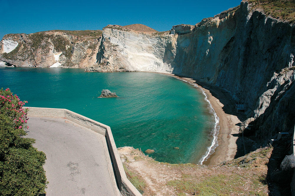
Before dusk we took the only concrete road behind the settlement, and within minutes we were out on the west side of the island, just behind the port. Here there is also the famous Roman tunnel which, after about 60 meters, leads us to the most beautiful and impressive coast of the island, Chiaia di Luna.
The vertically cut gray-white rock that hugs the wide, arc-shaped sandbank, tumbles vertically from a great height, composing a fascinating coast, and - without a doubt - is the most popular point of Ponza. Very often, however, it is forbidden to approach it and bathers to stay on the beach, due to the accidents caused by falling rocks that detach from the vertical walls of the coast.
Nevertheless, it still attracts a lot of people. Especially when there are no westerly winds, the whole bay is flooded with pleasure boats, whose crews enjoy their swim in the wonderful colors created by the reflection of the visible rocks in the calm waters.
We enjoyed the wonderful coast until sunset, when the colors become even sweeter and more impressive. It was already dusk and we returned to the port settlement which, under the lights that started to come on, takes on a more fairytale dimension, with the colors of the houses looking even more vivid and intense.
We sat until late, enjoying the special atmosphere of this place, and only when our strength began to leave us, we headed for the inflatable. In the same small boat we were taken to the boat, we untied, and after a few meters we again anchored on the northern side of the bay this time where it is quieter, while the sloops do not have time to create waves, which happens further south of the bay.
The entire bay, of course, is full of boats that stay overnight because, in addition to the fact that there are no free places on the floating platforms, the prices in the summer months skyrocket, exceeding 10 euros per meter.
Making the circuit
The next day was dedicated entirely to discovering the seaside attractions of the island. Ponza, having shed the stigma it carried from Roman times - but also from the modern era - as a place of exile, is now a very popular travel destination. And of course this is not just a coincidence, since apart from its archaeological interest and its excellent settlement, it is famous for its very beautiful coasts, the unique rock formations that often emerge from the deep waters and create natural works of art as well as for the its very beautiful caves.
The island is crescent-shaped, with its concave side facing east, thus offering very good anchorages, since the winds of the summer season have west-northwest directions. Its perimeter does not exceed 11 nautical miles and its strongly lacy coastline hides many beautiful surprises.
Leaving the port, we first headed to the southern tip of the bay. Near the white lighthouse, at sea level, we find the first traces of Roman civilization. Here are the famous caves of Pontius Pilate, which are intricately carved into the solid rock. From a distance they look like large arches in a row, which lead to long narrow tunnels that go quite deep into the rock. These tunnels, which communicate with each other with smaller internal galleries, form a set of artificial pools, which were the private pools of women who came from aristocratic families. According to another version, these pools were used as fish farms.
We descended a little further south and passed fairly wide by the faraglioni della Madonna. Just behind these rocks is the open bay of Parata, which is one of the most beautiful spots on the island.
Although the coast is surrounded by rocks, without the presence of a beach, the whole bay is a wonderful green natural pool with crystal clear water. Throughout the bay the bottom is sandy, and the depths vary from two to seven meters. The sea here usually looks like a lake, and is home to many pleasure boats that are full of steam. So we too, not resisting the temptation of this vast pool, chose a more secluded corner near the vertical rocks of the coast and for several hours we enjoyed our swimming in the wrinkled sea.
After we had rested sufficiently, we again returned to the cove of the harbor, and passed close by its northern bay, which is essentially formed of scattered low rocks in a row, which terminate in the small islet of Ravia. From the harbor and up, to the northern end of the island, three more large bays form, all of them of great interest.
Right after the islet of Ravia stretches the bay of Frontone, which gathers a lot of boats. On its southern side there are two very small and narrow sandy beaches, while a little further on there is a beautiful and large pebbly beach on which there is a large restaurant.
Continuing further north, we reached Punta Bianca, where the all-white rock that emerges from the sea dominates and prepares us for the wonderful sight that we will face. We are in the Cove del Core, with the vertical white cliffs hugging the narrow pebbly coast offering a very beautiful and exciting sight.
A little further up is the small cove of Inferno where, although there is no beach, a wonderful bay is formed with green waters.
This bay is surrounded by unique white rocks that fall vertically into the sea and create a very beautiful image.
Climbing Punta Nera we come across one of the most beautiful faraglioni of the island: The famous Arco Naturale, a tall rock with a large arch on its sides, which looks like two giant feet emerging from the sea. Around the Arco Naturale the seabed is lined with lovely sand, while the usually calm waters are enchanting and ideal for an overnight stay.
On reaching the northern cape of the island we carefully passed through the narrow channel formed by the islet of Gavi, and turned to its western side.
Here too there are very beautiful bays that stand out for the special formations of the rocks that surround them but we can only enjoy them when the sea is calm because they are affected by the western winds. Even winds of 3-4 Beaufort create a rather annoying wave, which does not allow us to anchor in the beautiful spots and spoils the overall image of the coast.
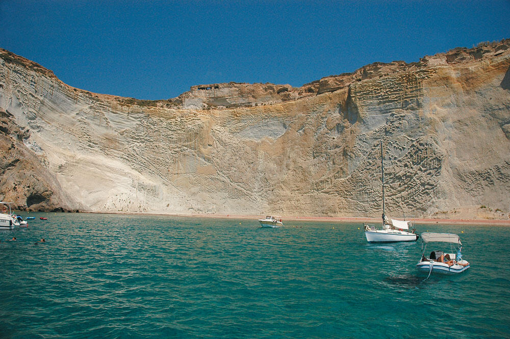
Two nautical miles from the northern cape we are at the beautiful Cala Feola. It is full of boats and we have to maneuver between them to get to the small beach located on the south side of the bay. A small breakwater provides some protection from the westerly winds, but even so, spending the night at Cala Feola is not safe.
The famous natural pools are also formed on the western side of the bay. These are two round openings in the rocks, which communicate with the sea and gather a lot of people.
Immediately south of Cala Feola is another famous bay, Lucia Rosa, which offers us some of the most impressive images of the island. Especially its southern bay, where many rocks are scattered -in which we often find large arches-, offers us a very beautiful sight. The long pebbly beach at the mouth of the bay attracts a lot of people, although there is no land access.
Apart from her beauty, Lucia Rosa is also known for the tragic fate of the girl who had the same name and fell from these rocks, ending her life as she was forbidden to marry the man she loved.
Lucia Rosa is now a symbol for the human rights of all women in the world.
A nautical mile to the south juts the promontory of Capo Bianco, the all-white bulk of which tumbles steeply into the sea, and after Capo Bianco our bow turned eastward. We slowly entered the fascinating Cove di Luna, this time enjoying the beautiful vertical cliffs of the coast from the sea. To the south of the bay dominates the mountainous mass of Monte Guardia, the peak of which is the highest on the island (280 meters).
It was after midday when we rounded the southern cape of Ponza and returned to port, intending to refuel. Unfortunately for us, the gas station was closed, as we were told that the last stocks of gasoline had been used up. Which was obviously due to the countless boats that are currently on the island. But the worst of all was that no one knew if the gas station would open in the next few days...
In vain we inquired whether we might secure even a few quarts, which were necessary for our passage to Corsica. Finally, in order not to waste the day searching, we decided to travel to the neighboring island of Palmarola, leaving the fuel problem for later.
In the "diamond" of Pontine
Palmarola is the westernmost island of the Pontine Islands and is only five nautical miles from the southern cape of Ponza. Despite its small size, it is a very popular destination that is flooded with yachts. It was a surprise island for us and it is certainly no exaggeration that it is called the "jewel" of the Pontine Islands.
With extremely steep and imposing coasts, very beautiful caves and above all crystal clear waters, it is without a doubt an excellent destination. If we are lucky and when we visit there is complete apnea, then it is certain that we will be enchanted by its spectacular shores.
Most boats anchor on the south side of the island, which is very well sheltered from the westerly winds. After all, this side is also the most impressive of the island, with the visible white rocks falling vertically into the sea from a very high altitude. The sight is fascinating, especially if we anchor near the vertical rocks.
The entire south side of Palmarola is a large bay which hosts dozens of boats, many of which even spend the night here. Two very large rocks located on the western side of the cove offer protection from the westerly winds and stop the waves from reaching the cove, where the waters are perfectly calm.
We anchored on the eastern side of the bay, just behind the low long narrow rock that, like an all-white blade, rises from the depths. We enjoyed the crystal clear waters for quite some time and had the strong feeling that we were in a large natural pool. We swam a few meters to the two very small sandbars formed at the base of the towering vertical rocks, where the sight was breathtaking. Looking up, we were in awe of the all-white rock that rises vertically and reaches a very high altitude.
The west side of the island is also very impressive and it is really worth visiting Cala del Porto, where both seasonal tavernas are located. It is the only point on the island where the steep shores are interrupted and we can go out for a short walk. As long as the weather permits, of course.
Unfortunately for us, it was impossible to approach, so we turned to the north-east side, where an open bay with green water forms. In contrast to the coast which is paved with large stones, the seabed is sandy and the waters defiantly clear.
We dived in without a second thought and as soon as we dived in we couldn't believe our eyes. I don't remember if we have swam in clearer water, but it was typical that we could clearly distinguish every grain of sand, while the anchor chain was clearly visible on the sandy bottom from tens of meters away. The incredible visibility of the waters made us swim for a long time, enjoying the crystal clear sea and experiencing an incredible experience. In fact, our excitement was so great that we decided to stay here until sunset.
So we turned on the radio, filled our glasses with local red wine and prepared our pasta on board, enjoying an incredible meal on the inflatable that seemed to float in the clear green waters. Only when the time passed did we begin to realize that it was our last day in these parts and the next day we would be crossing the Tyrrhenian Sea...
In Italy for refueling
So fate had to regroup, interrupting this wonderful carefree of ours, and so we started counting miles and calculating our fuel. We had 160 nautical miles of open sea to cover to the Lavezzi Islands in Corsica and the 320 liters of petrol in our tanks, although it was enough, did not allow us to be complacent.
In nearby Ponza, however, there was no fuel.
We opened the maps and looked for the nearest supply point. Finally we chose the coast of Italy, and our bow turned northeast towards Capo Circeo, where the marina of the same name is located 20 nautical miles from the northern end of Palmarola.
We intended to spend the night there and the next morning to attempt the long passage to the Lavezzi Islands which are on the opposite side of the Tyrrhenian Sea, at 173 nautical miles.
Wanting to catch the night, we were traveling at 32 knots and still had 10 nautical miles to Capo Circeo when the crimson sun began to sink into the Tyrrhenian Sea.
It was already dark by the time we were out of the marina's shallows and very carefully crossing the walkway leading to its entrance...
...keep Ribbing!