Crossing Baffin Bay and our short passage through the Other World
Crossing Baffin Bay and our short passage through the Other World
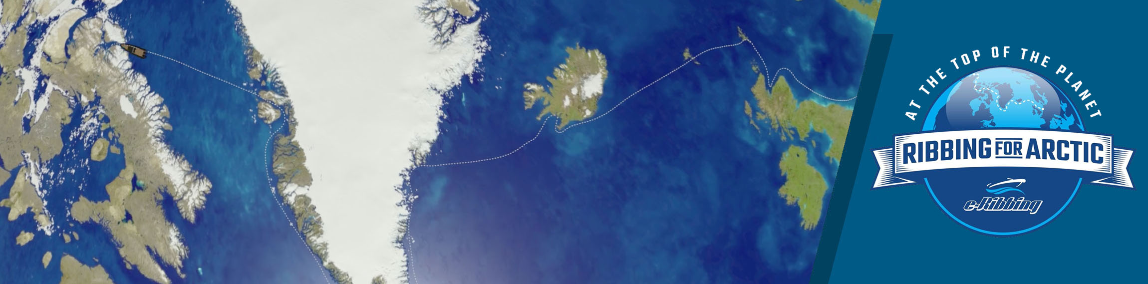
The last 650 miles of the expedition with the final destination of Nuuk
Go ahead to the direction of insecurity.
Where there is no road.
And leave your own mark.
This is the only road worth traveling…
We may have experienced “uncharted” moments with incredible intensity, but we also saw magical images that never imagined existing. Another, entirely different world, at the top of the planet, where man hasn’t put his hand yet and apparently never won’t be able to because Mother Nature has a very hard face in these latitudes.
We really experienced nightmare moments which were overwhelmingly much more than the good ones.
We were in danger many times.
Alone in... Another World.
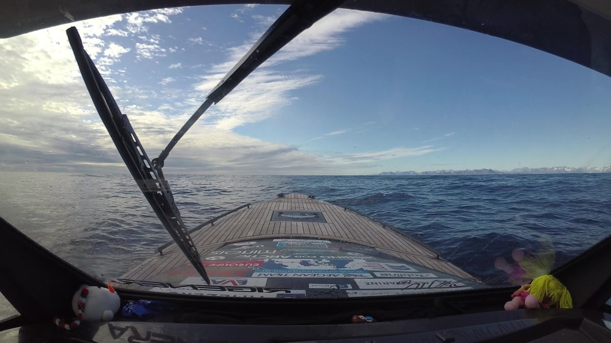
We faced the worst seas in a completely inhospitable environment and even worse having them upwind. Endless hours of navigation until our limits are exhausted.
And then, the icebergs and the infinite small pieces of ice that combined with the very dense fog created unspeakable cinematic scenes.
We got trapped several times, in the middle of nowhere, in vast frozen areas.
However, sometimes if you live something so magnificent it makes you forget the price of your effort to fulfill your goal...
DAY 45th - Tuesday, August 16
Position: 72°47΄N 56°09΄W – Upernavik
It was 11:45΄ in the morning, when after 29 whole hours of navigation we finally managed to approach the port of Upernavik.
We headed first to the gas station for refueling and then to the market for the necessary food and water.
We were out of energy and completely exhausted from our incredible yesterday’s adventure. All we wanted was to fall asleep.
But the weather forecast showed deterioration for the next day and so we had to overcome our unspeakable fatigue and continue to Ilulissat during the “night”.
We gritted our teeth once more and at 18:30΄ we left Upernavik at our stern and started to cover another 250 nautical miles.
We intended to steal some sleep during our course, as the good weather conditions allowed it.
At 23:30΄ we were halfway and entering the Disco island channel.
But this time the light began to diminish as the days began to shorten and so we traveled with great caution in semi-darkness.
Inside the channel, the sea was calm, so we found the opportunity to take turns sleeping every hour.
DAY 46th - Wednesday, August 17
Position: 69°13΄N 51°05΄W – Ilulissat
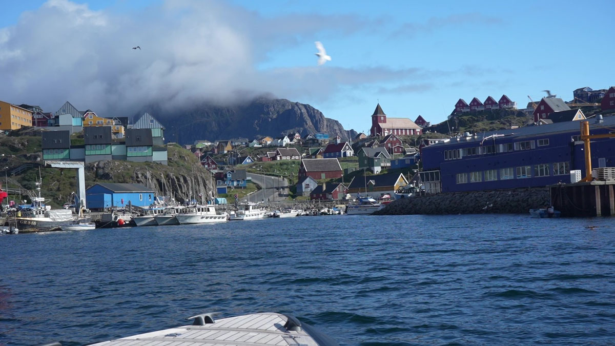
At 06:30΄ in the morning we slowly entered the busy port of Ilulissat.
We had recorded another 12 hours of riding and could no longer stand on our feet. We fell right to sleep in our warm cabin.
We got up at 13:00΄ after the noon and went to refuel at the gas station located on the floating platform of the port.

The rest of the day, in the thick fog and constant drizzle, we walked the streets of Ilulissat wandering around places we hadn't had time to visit last time.
Early in the evening we returned to our little cabin to fill in the hours of sleep we missed so much.
DAY 47 - Thursday, August 18
Position: 65°49΄N 53°20΄W – Kangaamiut
At 09:00΄ in the morning, we set off to cover another 250 miles to Kangaamiut.
The sea continued to be calm and thus we were able to travel comfortably.
At 15:00΄ after the noon we entered the port of Sisimiut to refuel.
Unlike our first visit, we were greeted by a clear blue sky and thus had the opportunity to take some beautiful photos.
But we didn't stay a lot because the north winds would strengthen in the afternoon and so we didn't have enough time at our disposal.
At 16:00΄ we left Sisimiut behind and set sail for Kangaamiut, 75 nautical miles further south.
In the middle of our route, north winds caught up with us, which made it quite difficult for us even though we had the waves at our stern.
But we didn't care and we turned our bow once to the west and once to the east playing with the ridges of the big waves.
At 19:30΄ we approached the dozens of islets that surround the small village of Kangaamiut.
However, we did not choose to approach from the south, where the port is more easily accessible, but from the north.
We wanted to wander between the very narrow channels of the numerous islets that surround it to the west and north, completely sheltering it from the west and north-west winds.
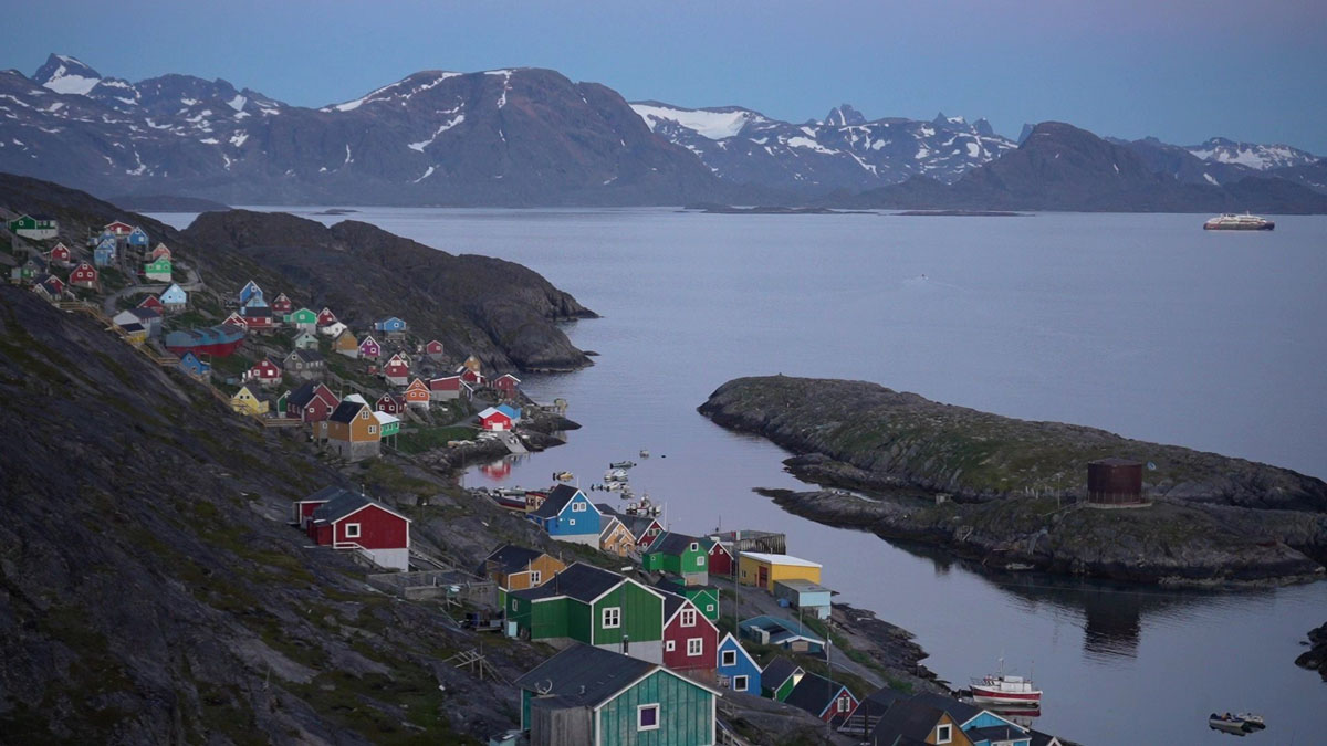
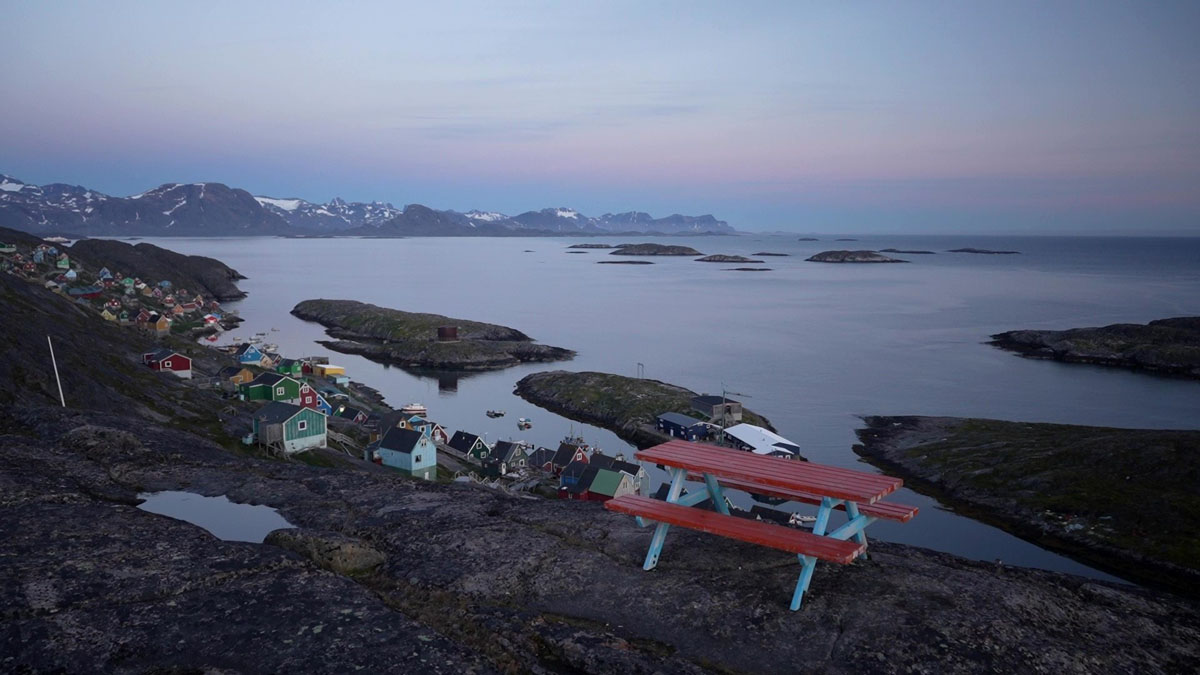
The waters were completely calm inside the narrow channels giving us unique images. Descending slowly into the northern channel, on our left the first houses appeared of the settlement that were built on the slope of the rugged rocks.
Everything indicated that we would see a wonderful village.
The entire village is built along the rocky slope and descends steeply to the sea.
Three long narrow islets, with a total length of one kilometer, protect and hide the village, forming a very narrow and long channel that is also the port of Kangaamiut.
Along the channel, from end to end, low and colorful houses are built whose view from the sea is breathtaking.
Everywhere you look you see a wonderful picture that exudes an aristocracy aura that we were not used to on these shores of Greenland.
It was obvious that this small settlement of 250 inhabitants has something different from the others. Perhaps because it was a whale hunter’s center many years ago, most of its population moved to neighboring Maniitsoq a few miles to the south.
We entered from the southern and very shallow entrance of the long narrow harbor so that we could see the whole village, navigating alongside its colorful houses.
A feast of colors everywhere we looked.
It was by far the most beautiful village we had visited so far.
We docked at one of the two floating platforms where the local boats are located, a few meters before the gas station, and obviously fascinated we went out to walk the main street that runs along the shore and crosses the entire settlement.
Everything was perfectly arranged and spotlessly clean, which made a huge impression on us.
A number of small houses may have been abandoned, but most of them were well maintained and seemed to be used mainly as summer residences.
We walked to the northern end of the village and then took the uphill path that took us to the top of the hill.
From here the view of the village and the numerous islets that surround it is amazing. We stayed for a long time to admire this unique landscape, speechless by the enchanting images that it generously gave us.
The absolute peace between the impressive rocks and the narrow channels was so majestic that it took us to another, completely different world.
Perhaps it was the best gift we could receive and God was saving it for us at the end of our mission.
Absolutely captivated, we decided to spend the night here, extending as much as possible our stay in this magical place.
DAY 48th - Friday, August 19
Position: 64°10΄N 51°43΄W – Nuuk
At 09:00΄ in the morning we left behind this wonderful place and with wonderful feelings we set sail for Nuuk, 125 nautical miles further south.
The sea was wonderful and so in 5 hours we were approaching the capital of Greenland.
This was also the end of our mission.
But we didn't want to get the boat out of the water quickly.
The day was beautiful and we preferred to extend our stay on deck for a while.
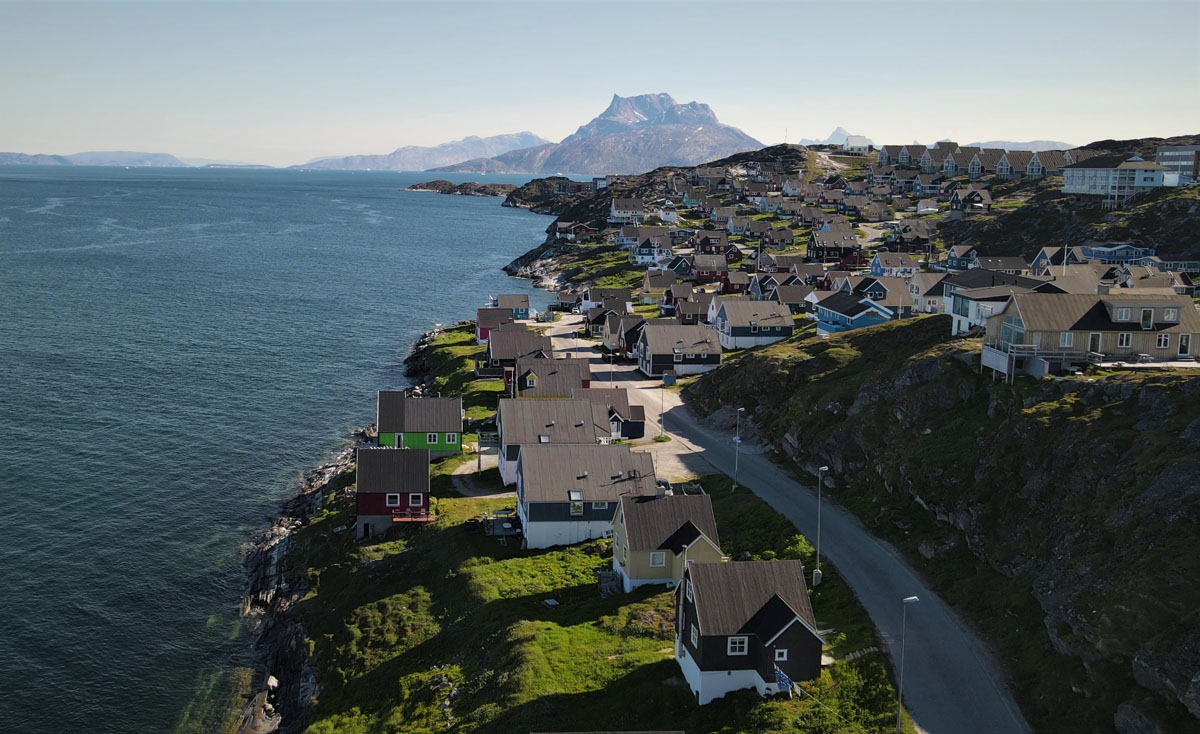
We stood for an hour outside the old city of the capital which is on the north-west shore.
We took out the tools, brewed the last cup of coffee and speechlessly gazed at the traditional houses of the wonderful old town, recalling the unique adventures that this trip to the top of the planet gave us...
Life is yours.
Don't let anyone mutilate her.
Build your own world.
Dive deep into it and chase your dream.
At all costs!
...keep Ribbing!