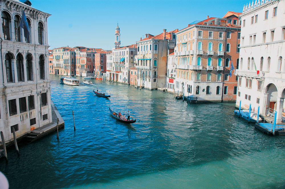
At the canals of Venice
Exploring North Dalmatian coast (Part 4)
At the canals of Venice
Exploring North Dalmatian coast (Part 4)
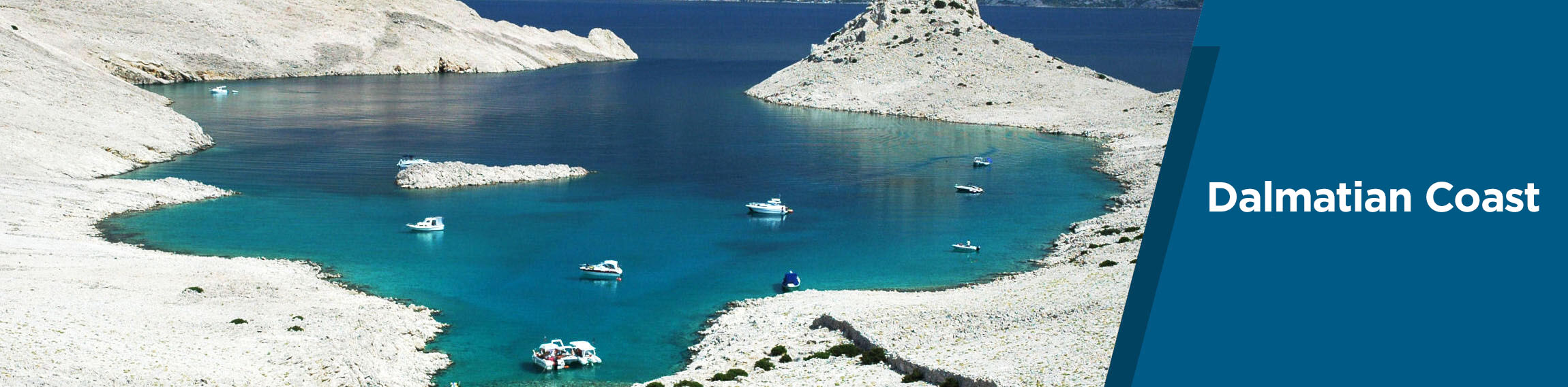
At the islands of Kvarner bay and the peninsula of Istria
At the islands of Kvarner bay and the peninsula of Istria. At the region of the bay, which effectively divides the Dalmatian coast of the peninsula of Istria, we find the largest islands in the Adriatic: Krk, Rab, Cres, Losinj and Pag.
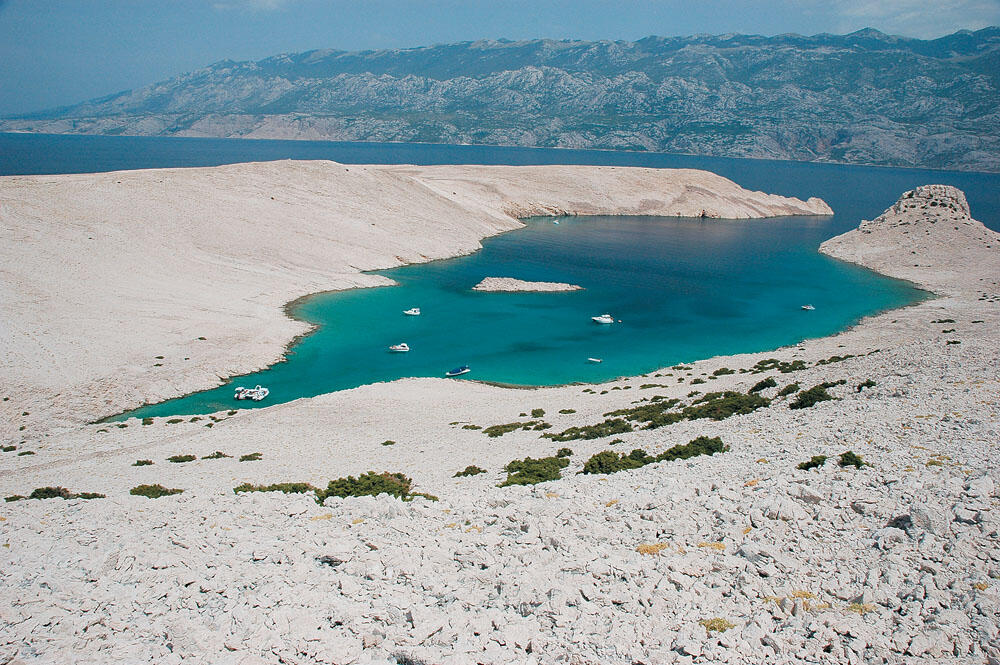
Pag
We were approaching the Pag Island, in which only the northern part belongs to the province of Kvarner. It is the third largest island in the archipelago with 32 nm length and its inhabitants approaching 8.000. To the southeast it is connected by a bridge to Croatia and is characterized for the beautiful small villages and quiet shores. The biggest part of the island is rocky, with the exception of some small areas covered by low shrubs.
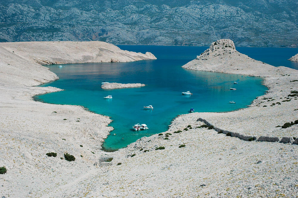
On our way we met several nice beaches, but we had set as destination bay Svetojanj, on the other side of the island. It is a place of truly unique beauty, and is 10 nm south of the Northern Cape. Quite soon we were out of the narrow entrance of the bay beneath the white wild rocks.
It is worth noting that from this point and below Velebitski kanal begins, which separates the island of Pag from Croatia. It is a very "infamous" part and probably the most dangerous of the entire Adriatic, because of the wind called «Bora».
This wind is going down from the tops of the Croatian mountains, usually without any warning, and often with terrifying power. Local fishermen say that when they smell the pine trees from opposite sides, Bora is coming. However this warning lasts for few seconds since Bora comes almost simultaneously with the smell of pine.
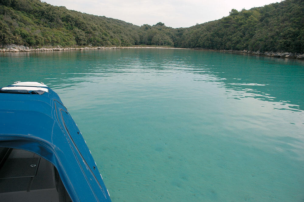
The bay Svetojanj is divided into two parts by a narrow strip of land that its end abruptly raises to 40 meters high. Thus two separate inlets are formed, a small and a large one. As we were entering slowly in large bay located north, we found ourselves in a much closed basin with turquoise waters, embraced by whitewashed rocky hills. The shape of the basin, the dazzling white colour of the rocks that surround it, as well as the wonderful colour of the sea creates a stunning image. A picture highly attractive, from those we have not been used to seeing before. Walking on the sharp rocks we reached with great difficulty at the top of the tallest hill, where for a quite long time we admired the astonishing landscape.
Rab
After enjoying the beautiful waters of this unique bay, early in the afternoon our bow was heading on the island of Rab. After 6 miles we approached the southern Cape and entered the narrow channel formed between the elongated island Dolin and the island Rab. Inside the channel, which extends for 5 nm about, there are many small beaches filled with people. Arriving at the other end, the harbour of the old town of Rab is gust opposite.
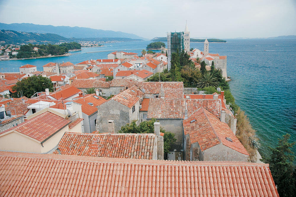
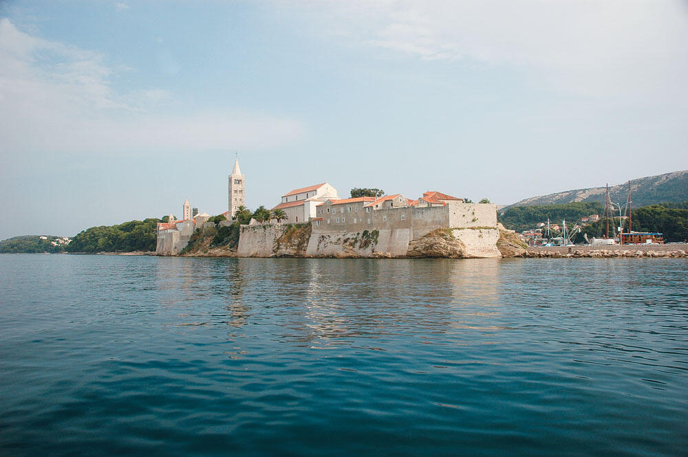
We tied up in Aci marina located there. We went for a walk in the old town which is a few meters away from the marina. It is a typical small medieval town surrounded by tall impressive stone walls. Built on a narrow triangular peninsula, between the Bay of St. Euphemia at the west and the harbour at east, is an important historical and cultural centre of the island with many important stone buildings. But what characterize it are the four majestic towers that seem to emerge from the roofs of houses.
After having walked for some time in the beautiful cobbled streets, we headed to the southeast end of the small peninsula, where the region Kaldanac is, the oldest part of the city. We went to the most important monument, the Cathedral St Mary, built in the 12th century. From here the view over the roofs of houses to the sea is breathtaking. Towards the north side of the city the amazing park Komrcar is clearly distinguished that is created 100 years ago, ideal for walks amid the dense vegetation and the tall pine trees.
Apart from the old town, there are many excellent places on the island, as well as many historical monuments and archaeological sights. Even here we can find ancient Greek ruins with great interest.
The eastern side of the island is rocky and barren, because it is exposed to savage moods of Bora that sometimes blows with incredible power. On the west side the landscape changes as tall hills protect the area against the gusts of Bora.
Dense vegetation adorns the variable coastline forming many deep and narrow coves with green waters and sandy beaches.
The Rab Island is an island that combines everything and is one of the most popular destinations in the Adriatic. Definitely it is worth spending some time exploring it.
Cres - Losinj
Our bow was heading the southern end of the Cres Island and our compass was showing 235 degrees. We were travelling with 21 nodes on a grey day with drizzle. We passed by north of the islet Trstenik and approached the cape Kolorat, which is the southern tip of the entrance of a very large bay inside of which there are four smaller bays, which gradually get narrow with great length, forming safest bays ideal for night. It is so narrow at some points that in combination with the green waters, surrounded by lush vegetation, you get the feeling that you are in a river.
We took the maps and carefully studied the coastline of the islands Cres and Losinj. There are two elongated islands with direction from north to south, separated by a narrow channel with width of a few meters. Cres extends for 40 nautical miles, with the homonymous settlement located at the north-western part of the island. It is built on the northeast side of a closed and large bay that provides security at all times. The beautiful houses and the wide sidewalk beside the harbour make up a very nice destination.
Losinj stretches 17 nautical miles, along with Cres. Approximately in the middle it is getting very narrow, where its width does not exceed 200 meters. On the eastern side of the narrow strip Mali Losinj lies, this is the main settlement on the island. A very beautiful place with beautiful buildings of the 18th century is protected well in a large natural bay. Particularly attractive is the old town situated around the church St Mary and attracts many people.
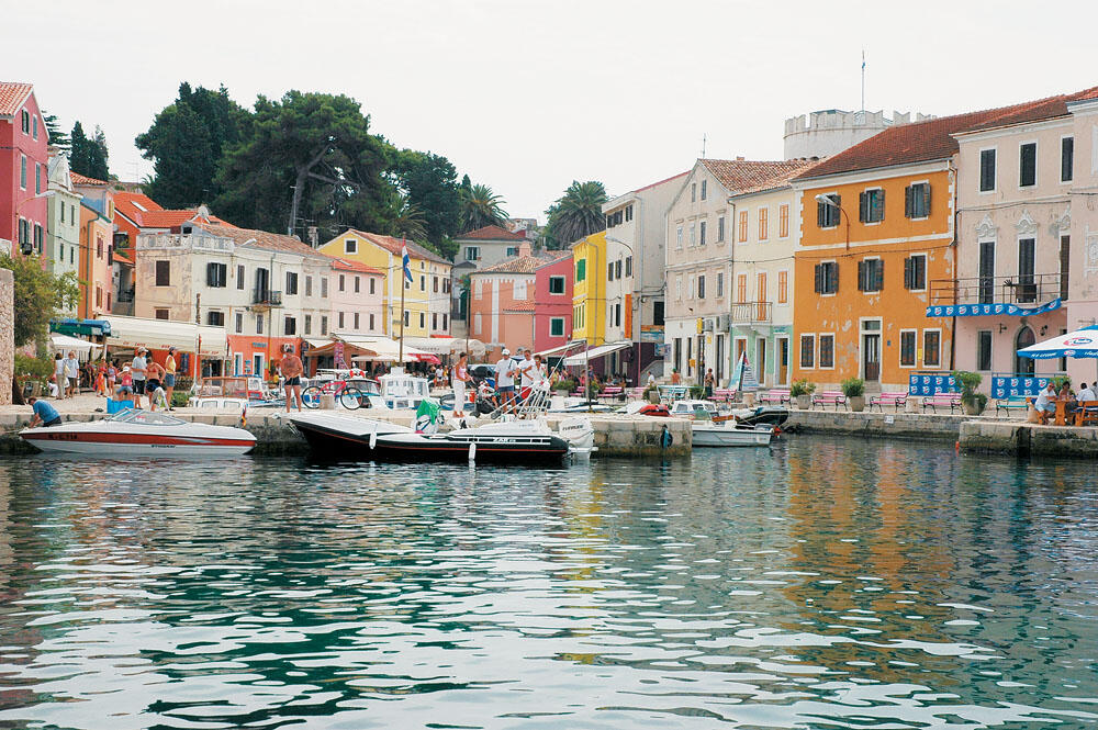
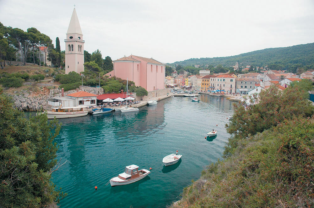
The second one important setlemment is Veli Losinj, situated on the west side of the narrow strip of the island. Veli Losinj is a quiet and picturesque village.
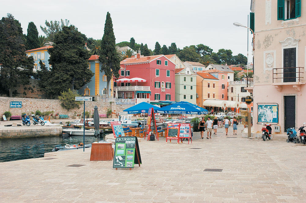
Wonderful houses in amazing pastel colours are situated one beside another at the narrow harbour which is filled with small fishing boats. At its entrance the church of St. Anthony dominates with the imposing tall tower, seeming to welcome us.
We felt that we were in a small canal in Venice, a little fairy party, a wonderful marine neighbourhood. With much difficulty we found to tie up on a tip and went for a walk in this beautiful corner of the Adriatic.
After having walked for some time in the charming streets, we returned with a lot of fun in the rib and our bow was heading the narrow channel that separates Cres from Losinj. We planned to go through it and head to the peninsula of Istria. But when we reached we realised that we should pass under a very low iron bridge. We unscrewed the antenna of VHF and finally managed to pass marginally.
Without any exaggeration, the roll bar of the rib was just 5 cm below the bridge.
At the peninsula Istria
We covered 2.5 miles to Cape Osor, which is the northernmost tip of the island Losinj. We got a new course to 277 degrees. The sea was very good, but the horizon was grey and dingy. After a while a thick cloud of fog was coming toward us, covering everything. The landscape changed immediately. We travelled to a mystical and quite inhospitable environment. Fortunately our visibility was pretty good, but of course not exceeding 300 meters. After several miles driving in fog, the visibility slowly began to improve.
We were approaching the largest peninsula in the Adriatic, the northern part of which belongs to Slovenia. In Istria we find many important monuments of the Roman era, which attract the attention of many tourists. The most popular areas of the peninsula are Porec, Rovinj and Pula, and are all located on the west side, which is the most developed. At the rocks of the southern headland, not exceeding 12 meters in height, several caves are formed, on which many tourists attempt spectacular dives.
There were only 9 miles left to reach the entrance of the large natural bay hosting Pula. Cruising near the coast we were entering the large bay, the entrance of which faces NW. We travelled more than two miles until we reached the end of the bay where there is the Aci marina where we tied up.
A few meters away the majestic Roman amphitheatre stands, which is one of the largest currently available and perhaps the best preserved in the world. Its walls reach 30 meters high and a capacity of 23,000 spectators. It is a centre of cultural events and hosts the film festival.
The old town of Pula is located south of the Roman amphitheatre and is of a great interest. Large shipyards however, the giant iron vessels and generally the biggest part of the harbour has become an industrial area that degrade very much that historic city.
Having wandered the streets of the old town, we returned early in the inflatable as we were intending to pass across Italy in the next morning.
...keep Ribbing!